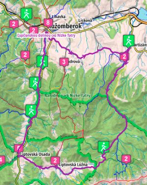
ROUTE:
Ružomberok – Partizánska Ľupča – Železné – Liptovská Osada – Ružomberok
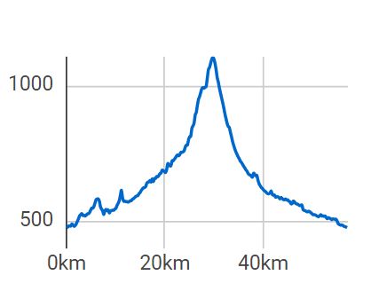
A good place to start can be Ruzomberok, but you can start anywhere on the route. If you start in Ruzomberok, you leave the town on an asphalt road alongside a beautiful church that is open during the summer season and continue on Liptovska Stiavnica, which is left behind in a short but steep climb. Followed by a move on the panel road to Liptovske Sliačov, a little rest on the asphalt road and again climb the field road to the hill before Partizánská Ľupča. From this village you continue along the asphalt road through the Ľupčianska valley in a gentle slope, which, however, takes on the intensity and elevation at Železná, although it can take on the asphalt road. Followed by a long downhill, views of the ridge of the Low Tatras, walk along the water meanders and in the descent you can also walk through the longest village of Liptov – Liptovská Lúžna. Along the plain and the asphalt road you will reach Liptovská Osada, from where you continue on the field road to Podsuchá, where the asphalt cycling trail starts, which will take you back to the beginning of the route to Ružomberok.
Paid and free parking is available in Ružomberok. There are regular bus and rail services to the city.
Accommodation and catering services can be found directly in Ružomberok or in the villages through which you will go.