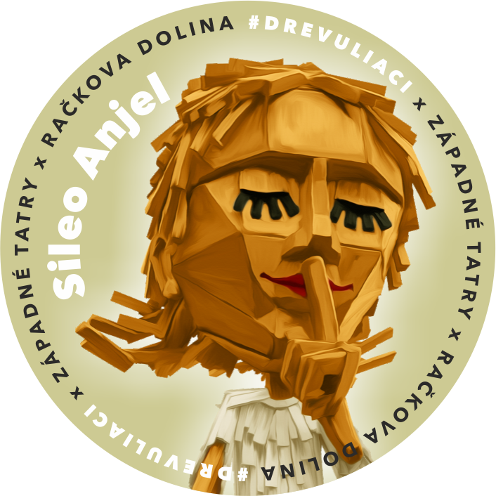
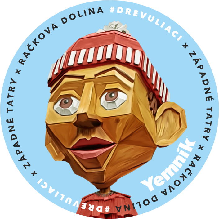
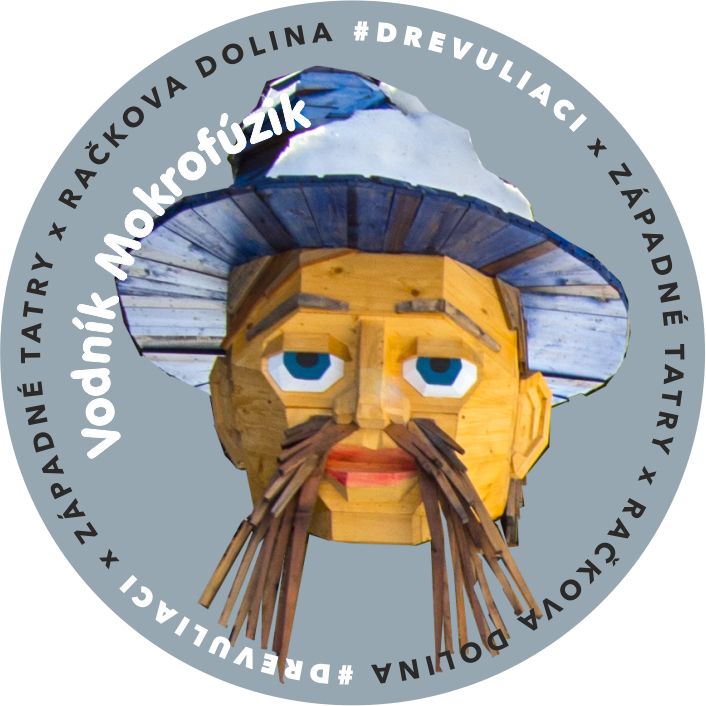
Discover the Drevuliaci with your children. These are seven oversized wooden sculptures set along a hiking trail in Račková Valley near Pribylina.
Along the route, you’ll meet the shepherd Račko with his grandson Plačko, an angel whose wing brushed against Kriváň, the lazy mushroom picker Fero resting in a basket, the stubborn Yemník guarding the entrance to the Narrow Valley, Pionierka Vierka, who found eternal youth here, and the water goblin Mokrofúzik. Each sculpture has its own story – some are humorous, others mysterious; all are authentic.


At the entrance to the valley, a painted map shows the exact location of all the sculptures. Set out to find them – children can tick off each one they discover.
Enjoy a walk in the fresh mountain air as you take in the calm atmosphere of the Western Tatras and the scent of spruce forest in the picturesque Račková Valley.
The Drevuliaci were created in 2017 as a community project without grants or subsidies. They are the work of woodcarver Michal Hanula, who can create virtually anything from wood – the result is remarkably lifelike. The sculptures reach up to four metres in height and weigh around 300 kilograms.
The route is approximately 5 km long, easy and suitable for the whole family. Entry is free and the trail is accessible all year round.
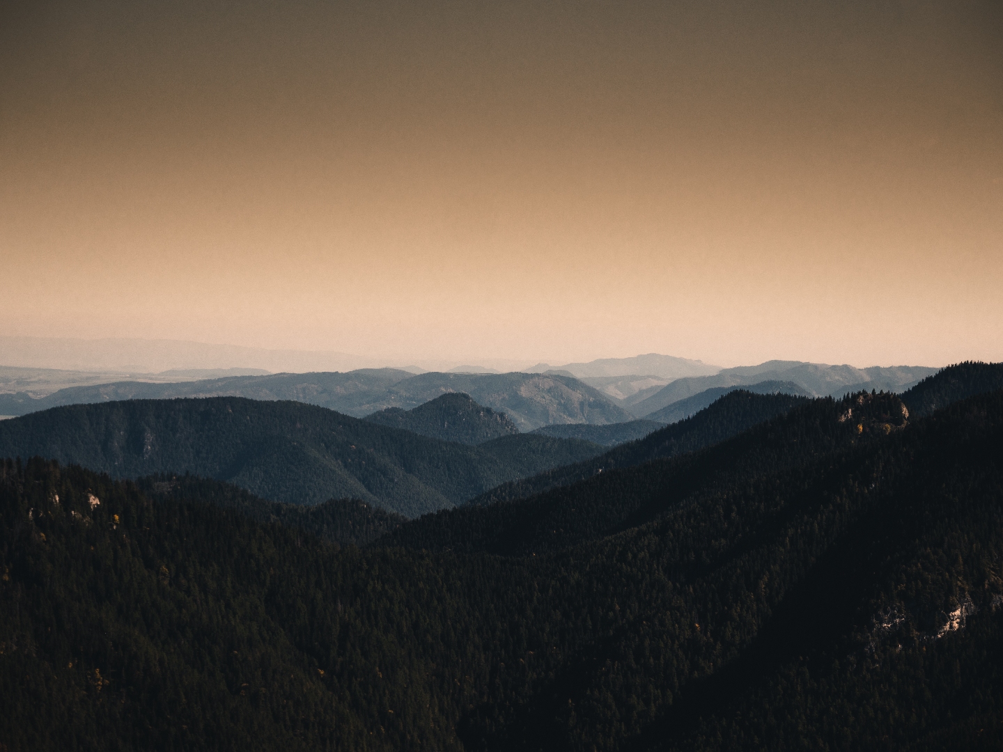
The viewpoint on Predny Čebrat is one of the most sought-after places, especially by locals. The view from the top provides a unique view of the city of Ružomberok, the Liptov Basin and the surrounding mountains. The ascent route to the peak is named after Zdenek Hochmuth, in whose honor a memorial plaque is placed on the peak. The peak is accessible all year round and the climb to it is slightly more difficult.
The starting tourist signpost is located next to the road, between the bus and railway stations in Ružomberok. A green marked tourist route leads from the signpost to the top. The markings lead us past the bus station, after which we turn right to a railway crossing for pedestrians. Behind the tracks, it continues left, parallel to the railway line. It passes under a bridge, after which we turn right into the forest in front of apartment buildings. The trail leads alternately between trees and small meadows, past a well to the Hlivovo recreational meadow. It continues left on it. If interested, we can rest in a shelter with seating on the meadow. The trail leads us from Hlivovo to a forest road, from which, however, after about a hundred meters we turn right into the trees. A steeper path through overgrown felling will lead us to the forest. A gently ascending, winding trail then helps us to overcome steep slopes. At the end below the summit, the trail splits several times. We recommend always using the one with the lowest gradient to reach the destination safely.
Warning: The viewpoint on the cliff is not secured against falls.
Predný Čebrať rises north of Ružomberok. Its pyramidal shape forms a dominant feature visible from almost the entire city. It is 1.7 km (as the crow flies) from the city center. A green marked hiking trail leads to the top.
Transport:
By bus, public transport: stop “Železničná stanica”
By suburban bus: stop “Ružomberok,,AS”
By car: parking at the railway station
By train: station “Ružomberok”
Distance:
From the starting point between the railway and bus stations in Ružomberok 3.6 km.
Upon return, we can use the services of a restaurant, refreshments or catering service near the start of the route in Ružomberok. Accommodation will be provided by accommodation facilities in Ružomberok or Likavka.
The latest singletrail in Liptov region, directly above the town of Liptovský Mikuláš in the Háj-Nicovô forest park area named High flow, is about 800 meters long with an elevation difference of 100 meters, and will delight nearly all mountain biking enthusiasts. It is designed to be manageable for less experienced riders while also offering enjoyment for trail connoisseurs.
The start of the flow trail is located at the end of a meadow next to a military monument and is clearly marked with a wooden gate and directional signs. The ascent route for cyclists is along the official asphalt road to Háj-Nicovô, or alternatively, cyclists can push their bikes up the hiking trail on the side of the flowtrail.
The co-author of this fun and technically high-quality track is Adam Rojček, an ambassador of downhill cycling in Liptov, a 6-time Slovak champion in downhill and enduro disciplines and also the winner of the European Cup in downhill in 2023. It is also a community project involving many volunteers and enthusiastic riders, who have contributed significantly to the construction and final form of the trail.
Zaujímavosti v blízkosti trasy:
The route begins at the car park near the site of the Východná Folk Festival, which takes place in early July every year. There are several parking options around the grounds, but the closest car park is right next to the main entrance. It’s a short walk – just five minutes or so – manageable for children and less mobile visitors. The site also features an observation tower, wooden sculptures, a small children’s playground, and a snack bar offering refreshments – HybajHo. Please refer to the snack bar’s website for its current opening hours (which may be restricted in off-season months).
The Májka observation tower is open daily from July to September. Outside these months, entry may be arranged by phoning in advance. Guided tours of the tower and amphitheatre in Východná by a local guide are available. This is your chance to learn fascinating facts and hear intriguing anecdotes and stories from the amphitheatre’s history.
Babky (1566 m above sea level) is part of the Western Tatras, while the hike to them is not among the most demanding, but it is definitely one of the most beautiful. Especially the views of Liptov are worth it.
You start the hike to Babky at the beginning of the Bobrovecká valley, specifically in the Bobrovecká vápenica area, where free parking is available. The route follows the blue sign next to the calvary along the weighbridge through the Pod Babkami intersection to the Chata pod Náružím, where you can have refreshments. The route continues along the blue sign to Pod Babkami, from where you take the green sign to Babky. Grandmothers have a unique view. During the route, we can stop at a partisan bunker. This is a cave with photos and a description where the guerrillas were hiding.
There is a free parking lot with sufficient capacity right at the starting point of the route in the location of Bobrovecká vápenica.
The bus stop is about a 2.5 km walk from Bobrovecka limestone at the intersection with the village of Jalovec, which can be reached by suburban line from Liptovský Mikuláš.
On the way to the top, you walk past the Chata pod Náružím in Červenci, where you can have refreshments or sleep. The Mountain Hotel Mních is located near the starting point of the route. On the way from Jalovec, it is possible to visit Salaš Pastierska. In addition, there are designated sites for camping.
The route is parallel to the red hiking sign, with the exception of the detour to stop 3. At the end, the educational trail leads through a high mountain environment, where you need to be especially careful in the steep part. The last information panel of the educational trail stands in the Vrác saddle about 30 minutes from its destination at the top of Veľké Choč.
Names of information panels:
1. Lúčky village
2. National natural monument Lúčanský waterfall
3. Natural monument Lúčanské travertine
4. Spa Lúčky
5. Choč – Žimerová meadows
6. Choch – forest area
7. Choč – alpine range
The information panels in the field are not marked with the name of the nature trail.
Parking is possible in the village of Kalameny.
You can stay in Kalameny or Lúčky.
The route starts in the village of Kalameny and continues past the Kalameny lake (thermal spring), which is used for public bathing all year round. It is parallel to the yellow and, from the junction Sedlo pod Kráľová, to the red tourist sign. The route with a permanent climb leads largely outside the forest, which can be strenuous on sunny summer days. A 7 m high metal ladder and a bridge lead to the platform with the castle. There are warnings in the terrain: entry into the Liptovský Castle area is possible only at your own risk and for persons under 14 only accompanied by adults.
With good visibility, the hill and the castle offer views as far as Orava with Baba Hora, the Liptovská Basin with the Liptovská Mara reservoir, the Low Tatras and Veľký Choč (1,609 m above sea level). The castle area is a national cultural monument. The small remains of the castle (exposed foundations of the walls), which are being preserved by the local civic association Castrum Liptov, are freely accessible to the public.
Names of information panels
1. Educational trail Kalameny – Liptovský Castle
2. Flax and hemp
3. Water
4. Interesting facts about Liptov Castle
5. Forest
6. Geology of the Choč Hills
Information panels in the field (except for the introductory one) are not marked with the name of the nature trail.
There are also (three) faded information panels from the previous version of the educational trail (status in 2020) on the trail route. It is possible to return from the castle to the lake as a circuit following the (exposed and also steep) blue tourist sign (total 4.5 km to the exit in the village).
Parking is possible in the village of Kalameny or by the Kalameny lake. Parking is charged. From the bus station in Ružomberok you can take a bus to the “Kalameny,,kult.dom” stop, which is located right at the beginning of the route.
You can stay in Kalameny or Lúčky.
The educational trail Plieška (Cyril and Methodius path) will take us from the Spa Lúčky below the hill Plieška to the village Kalameny. The trail is connection between the natural thermal lake in Kalameny and the Spa in Lúčky village.
You can also get to the Spa Lúčky by bus. The route starts at the tourist crossroads Lúčky, Aqua-Vital Park, near the restaurant Kúpeľná dvorana. However, it is both direction-way. You will go along the edge of the forest along the blue-marked hiking trail at the southern foot of Plieška Hill.
The trail is moderately challenging and can be muddy and slippery on some places in colder weather. The route is only slightly difficult due to its length, elevation and terrain. Therefore, it is suitable even for small children.
A path with three educational panels will lead you to Kamaleny village. There is a natural swimming pool called a “pit”. The nature trail begins/ends at the rebuilt and adjusted pit with warm mineral water.
Information boards names
- Great Moravia
- Saint Cyril – Constantine
- Saint Methodius
Information panels in the terrain are not marked with the name of the nature trail. The design of the first and the remaining two panels differ.
Free parking is possible at the beginning / end of the route in the Spa Lúčky, or at the thermal lake in Kalameny. There are also regular bus connections to the villages from Ružomberok town.
In the villages of Lúčky, Liptovská Teplá and Kalameny there are several accommodation and catering facilities.
A journey along the traces of the submerged villages, forever buried by the waters of Liptovská Mara. This cycling thematic route offers not only sports activities and beautiful views but also interesting information about the water project that has significantly influenced the lives of thousands of people and forever changed the face and development of the entire region.
The loop starts in the center of the village of Bešeňová at the Infopoint, from there it heads to the dam of the Bešeňová Reservoir, then through the village of Vlachy to the dam wall, after which cyclists reach the church tower at Liptovská Mara, continue through the settlement of Tvarožná to the iconic viewpoint Kyseľovec. The journey ends in the village of Bobrovník near Marina Liptov and then returns along the dam wall to the historic building of the original railway stop in the settlement of Vlašky and back to Bešeňová. There are several steep climbs on the route, because of which we recommend completing it with the use of electric bicycles or more experienced cyclists.
Our tip: There are several uphill sections along the route, so we recommend tackling it with the use of e-bikes or for more experienced cyclists.
Everything changed with the idea of building the water project. From the declaration of the construction closure for the presumed flood area in 1950, through the definitive government decision to proceed with the construction until the completion and permanent use of the entire water project complex in 1976, the residents had to face many challenges. In a period of difficult struggles for their daily future, strength and the ability to withstand conflicting decisions and often unattainable demands were necessary. In the shadow of the future reservoir, a whole generation of people grew up on the threshold of the emerging new face of Liptov.
Below the water level of Liptovská Mara, there were a total of 13 historically independent villages, of which 12 were completely submerged by the reservoir. A total of 940 families, representing over 4,000 residents, were relocated. The thirteen vanished villages, of which only one was rebuilt, are fragments in the mosaic of life in Liptov. Through their names, recorded only in old maps, we also remember other villages that were significantly affected, positively or negatively, by the impact of this major construction project. It was necessary to relocate railway and road networks, reroute electric and telecommunication systems, establish new infrastructure for various areas of life, as well as create protective zones and safety measures.
The project was constructed between 1969 and 1975, and from the very beginning, its purpose was to mitigate flood torrents, improve water flow in the middle and lower reaches of the Váh River during dry periods, and generate electricity. Tourism development was a tertiary priority during the planning and construction stages.
Nearly 50 years have passed since the completion of the water works, and people are no longer afraid of devastating floods in Liptov. The region has become a popular tourist destination. Enjoy the magnificent views of water and mountains from the saddle of your bike and learn interesting facts and information about the history of the water project and its related context.
Also visit: The mini open-air museum of the submerged villages in the Koliba Gréta area in Liptovská Sielnica, where you can find valuable information about other vanished villages that are not included on this thematic cycling route.
Interesting POIs along the route:
Dúbrava, Štátne Majetky – trail to the south-east – mouth of the Dúbravská Valley – up the valley to the south – former mining plant and mining museum.
The trail follows an asphalt road purpose-built for use by large trucks, so please exercise extra caution!
The route starts at Štátne Majetky on the outskirts of Dúbrava, a historic mining village founded in the 13th century. Your walk takes you through the Dúbravská Valley, where you’ll find five information panels along the way:
- A brief history of Dúbrava village and its early mining heritage
- Geological characteristics of the Dúbrava deposit and the environmental risks of stibnite mining
- The oldest ore extraction techniques and stibnite processing
- Mining in Dúbrava during the 20th century
- Extraction and transport in Dúbrava mines in the 20th century
Around 6 km from the village, you’ll reach the site of the former mining plant in the Paludžanka Valley, located on the northern side of the Chabenec massif in the Ďumbierske Tatras. This is home to the most important stibnite deposit in the Czech Republic and Slovakia. Besides stibnite, small quantities of gold, silver, and copper ores were also mined here in the past. Mining activity intensified significantly after 1948, when a flotation processing plant with a capacity of 50 tonnes per day was established. To transport ore to the plant, cableways were built from the Predpekelná and Dechtárka sections, one measuring 1.4 km, the other 0.5 km. Stibnite from Dúbrava was a strategic raw material for Czechoslovak arms manufacturing. In 2023, the Mining Museum opened in the building of the former mining warehouse office – known locally as the banícka faleska – where miners once gathered before heading underground. The museum, offering an exhibition on the history of local mining, is open to the public at weekends from 11 a.m. to 2 p.m. by prior telephone appointment.
Dúbrava can be reached from the town of Liptovský Mikuláš via the local regular bus service, with the trail’s starting point conveniently located at the bus stop. If you are travelling by car, parking is available at several quiet spots along the roadside.
There are several accommodation facilities in the village and in the valley that offer accommodation. Dining options are provided, whether in summer or winter, in hotel restaurants or snack bars.
The route starts at the former Korytnica Spa, where you can refresh yourself with water from one of the springs before the walk. The water from the healing springs has a positive effect on stomach as well as digestive and metabolic problems. Jozef, Žofia, Antonín, Vojtech I a II springs all have highly mineralised water rich in calcium, magnesium and iron.
Follow the green way markers. The route leads along an asphalt road and on to a forest logging track. In less than an hour of pleasant climbing, you will get to a saddle under the Baba mountain, from where you are rewarded by views over the massif of Zvolen (Nová hoľa), a mountain located over Donovaly. After about three quarters of an hour of walking along the logging track, the forest begins to thin out, with the ridge of the Veľká Fatra (from Mt. Krížna to Mt. Suchý vrch) coming into view. On reaching the Hiadeľské sedlo saddle, the route turns left up the track marked by red waymarkers, ascending steeply through the forest, which gradually gives way to dwarf pines. It then continues along the tops of Mt Prašivá and Mt Malá Chochuľa, leading right to the summit of Mt Veľká Chochuľa. Veľká Chochuľa (1753 m.a.s.l.) is the highest peak of the western part of the Ďumbierske Tatry mountain range, offering nice views to all directions. It lies on the main ridge of the Nízke Tatry mountain range, with Cesta hrdinov SNP (the Path of the Heroes of the Slovak National Uprising) running along its summit.
Until 1974, there used to be a narrow-gauge railway running from Ružomberok to the Korytnica spa. In 2016, the disused railroad was turned into the Cyklokorytnička cycle path, which also serves as an educational trail for families with small children.
Mt Veľká Chochuľa can also be reached from Liptovská Lúžna by following the yellow markers, taking you through the Sedlo pod Skalkou saddle and Mt Košarisko straight to the summit.
You can park the car in the Korytnica village. The route is also accessible by bus – get off at the Liptovská Osada, rázcestie stop.
There are no mountain chalets on the way but there are many accommodation options available in Korytnica, nearby Donovaly and Liptovská Osada. You can have refreshments at the Penzión Svätopluk guest house in Korytnica and, of course, try the water from one of the springs in Korytnica or go to a shop and buy it in a bottle. The beneficial effects of the water were noted already in the 17th century.
The Šíp mountain is located in Šípska Fatra, which is a mountain range connecting the Malá and Veľká Fatra mountain ranges. It rises right above the confluence of the Orava and Váh rivers, between the villages of Kraľovany and Ľubochňa. The route starts in the Stankovany village, from where you follow the green markers. In about 30 minutes you will reach the Podšíp setllement, where you can admire its well-preserved, traditional wooden houses or just stop by for a picnic. From Podšíp, follow the yellow markers up through Zadný Šíp to the majestic cross on the summit of Šíp (1170 m.a.s.l.), from where you can enjoy amazing views of Veľký Choč.
The area of Šíp (302 hectares) has been designated a national nature reserve due to the presence of rare plant and animal species.
The route is accessible by car, bus and train. You can park the car at the parking lot in front of the Municipal Office in Stankovany. Stankovany railway station. Stankovany, Pri moste bus stop.
Refreshments and drinks are available at the Krčma Stankovany pub.
Veľký Bok (1727 m.a.s.l.) is a prominent mountain situated in the central part of the Kráľovohoľské Tatras. The mountain juts out of the main ridge and is higher than the ridge, so once at its summit, you can enjoy a wonderful all-round view. There used to be a mountain chalet called Veľkoboká chata in the saddle under Veľký Bok until the Second World War when it was burned down by fascists. The chalet was a part of a network of mountain chalets, lying between the Štefánikova chata pod Ďumbierom chalet and the Štefánikova chata pod Kráľovou hoľou chalet. It is still a missing link in the chain of mountain chalets in the Low Tatras. A small hunting lodge has been built on its foundations, but it is not open to the public.
Veľký Bok is not one of the most visited mountains, so if you are someone who likes wilderness and enjoys the challenge of wandering off the beaten track, this is the hike for you. It takes the whole day. The hike from Malužiná to the top takes around 4-5 hours and its 14 km long. First, follow the blue trail markers and when you reach the saddle under the Veľký Bok, follow the yellow trail markers.
The top can also be reached by following the route from Svarín (Svarín – Pod Chmelincom – Veľký bok and back), marked yellow. Similarly to the Malužiná-Veľký Bok and back route, the total length of this route is 28 km. This hike can also be done as a one-way hike from Malužiná to Svarín or vice versa.
You can park in both villages. The route is also accessible by bus – Malužiná, rázcestie (crossroad) bus stop.
There are no mountain chalets on the way, but there are several places offering refreshments in both villages. There should also be a spring above the hunting lodge.
The route to the summit of Radičiná starts in Ružomberok, Rybárpole and continues through a commercial forest to the Dubovské lúky meadows with traditional haystacks and a view over the majestic Veľký Choč mountain. The route then steeply climbs through the woods to the saddle and a glade with a fire pit. From there, it is only a short walk to the summit of the Radičiná mountain (1127 m n.m.), where you can enjoy a view over the Liptovská Mara dam.
You can also approach the Radičiná mountain from the opposite side, from the Komjatná village, Studničná part. You can park in Ružomberok, Rybárpole or in Komjatná. The route is accessible by bus and train. Ružomberok – Rybárpole stop.
If you wish to have refreshments before or after the hike, there are plenty of dining options in Ružomberok.
The route starts in the village of Partizánska Ľupča, which was once the oldest mining town in Liptov and whose square boasts an iconic church and burgher houses. The yellow trail marker will lead you out of the village to the Biela Ľupča signpost, past meadows and a fenced water reservoir. Keep right and enter the woods. Continue to the Rumanec signpost where there is a table with benches ideal for a refreshment break. The route offers nice views over the lower part of the Liptovská Mara dam, the Western Tatras mountain range and the Chočské vrchy mountain range. At the monument of the fallen soldiers, the route enters the woods and will take you through a meadow right to the top of the Predná Magura mountain, where you can find a reconstructed gazebo.
Predná Magura (1171 m.a.s.l) offers great views over the Liptov basin, nearby forested Ľupčianska Magura mountain, the main ridge of the Low Tatras mountain range and over Salatín, a mountain in the Low Tatras. This hike is ideal for families with small children and less fit walkers.
Free parking is available in the village or at the water reservoir. The village is accessible by local bus from Ružomberok or Liptovský Mikuláš.
There are no mountain huts on the route but there is a choice of accommodation in the Partizánska Ľupča village. Just a few kilometres away, there is the Železnô recreation resort with accommodation and a pleasant snack bar on-site as well as a popular Magurka chalet offering accommodation and dining.
Ostré (1067 m.a.s.l.), called Hrdoš by locals, is a rocky mountain visible from the main road leading from Martin to Ružomberok. The starting point for the hikes to Ostré are Komjatná (app. 2 km), Švošov (app. 3 km), Stankovany, Žaškov and Ľubochňa.
When starting from Švošov, follow the yellow trail markers to the Sedlo pod Ostrým saddle, from where a steep but only about 15-minute long climb will take you to the summit of Ostré. There are some trees on the summit but they do not obscure the views over Ružomberok, most of the lower Liptov and Orava. There also is a fire pit at the top.
The route from Švošov is also accessible by train. You can park the car in the villages.
This easy half-day tour to the Rovná Hoľa mountain will reward you with stunning views to all directions, especially of the Western and High Tatras. Follow the yellow marked trail that starts in the Nižná Boca village and continues up the valley where it joins the path leading to the saddle of the Črchľa valley where you can find a spring of fresh water. Continue through the forest and dwarf pines to the top of the Rovná (flat) Hoľa mountain (1723 m.a.s.l.). As the name suggest, its top is flat so when there, you can enjoy open views to all sides. Perhaps the most unique is the view of Ďumbier, of its steep walls and gullies leading to the Ďumbiersky Kotol basin. To the west there are views of the Chopok and the massif of the Bôr mountain and to the north you can admire the views of the limestone massif of the Ohnište mountain with its famous rock window.
You can also reach the summit of the Rovná Hoľa mountain from Vyšná Boca, Čertovica and Svidovské sedlo.
You can park in the village. The village is also accessible by bus.
There is a spring of potable water along the way to the saddle of Črchľa. You can have refreshments in the Nižná Boca village, for example at the Chata Barborka chalet located close to the lift. There are many accommodation options in the village to choose from.
Chabenec (1955 m.a.s.l) is a majestic mountain on the ridge of the Western Tatras offering views to all directions. The route starts in the Magurka settlement, where gold as well as silver and antimony was mined in the past. You can learn more about the history of mining by following the Magurský zlatý chodník trail which kids will enjoy as mush as adults.
Follow the green markers towards the Ďurková saddle. At the Nad sedlom signpost, follow the red route markers towards Malý Chabenec and to the top of Chabenec. Once you have had your fill of great views, you can return to the Magurka setllemenet using the same route or you can extend the route by walking to the Útulňa Ďurková mountain hut, which is located below Mt. Chabanec and is a popular resting place for people hiking the ridge of the Low Tatras.
There is free parking in the Magurka settlement, but the access to the settlement is via rural, narrow road that often gets icy in winter.
A popular Magurka chalet located right in the settlement offers both accommodation and delicious cuisine. There is also the Útulňa Ďurková mountain hut offering shelter for the night. The hut is mainly used by hikers crossing the ridge of the Law Tatras. It is located below the saddle, so you need to descend a few metres form the route to get there, but the refreshments and the atmosphere are worth it. Just a few kilometres away, there is the Železnô recreation resort with accommodation and a pleasant snack bar on-site.
Holý Vrch (1723 m.a.s.l.) is a less majestic and less known peak of the Western Tatras. There is a popular tourist route that will take you to the summit of the impressive Baranec Mount running through it. The peak is characterized by its pyramid shape and it is accessible all year round, with no seasonal closures.
The starting point for hikes to Holý vrch is either the Žiarska Dolina valley (app. 3 km along the yellow markers) or Jakubovany (app. 6 km along the blue markers). The summit is not marked, it is above a signpost located on the ridge leading to Baranec. It takes about 1,45 hour to reach the summit from there.
The route from Jakubovany starts near a former ski lift, continues along an asphalt road and past the cottages, where it turns left to the forest. Above the place where the trail crosses the Tatranská Magistrála touristic route, there is a signpost directing hikers to the Jakuboviansky Vodopád waterfall, which can be reached within 5 minutes. After visiting the waterfall, hikers need to return back on the trail and ascend to the top of the Tri Kolky Mount, where they can rest and enjoy the views of the basin. The second part of the route takes hikers on an energetic climb to the top.
You can park in the Jakubovany village or use the car park close to the former Jakubovany ski lift. You can also walk to the starting point from the final bus stop in Jakubovany.
There are no accommodation options on the way but you can have refreshments in the village, for example at the Jakub pub.
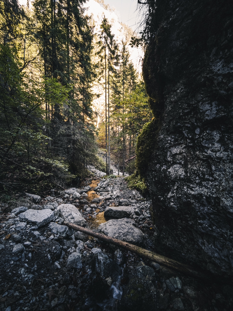
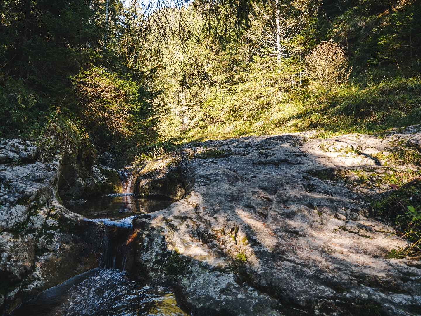
Although the Demänovská dolina valley is one of the most visited mountain areas in Slovakia, there are still places with not too many people around. One of such places is the Vyvieranie gorge, from where you can continue to the Pusté mountain, Krakova hoľa mountain and the Demänovská hora mountain.
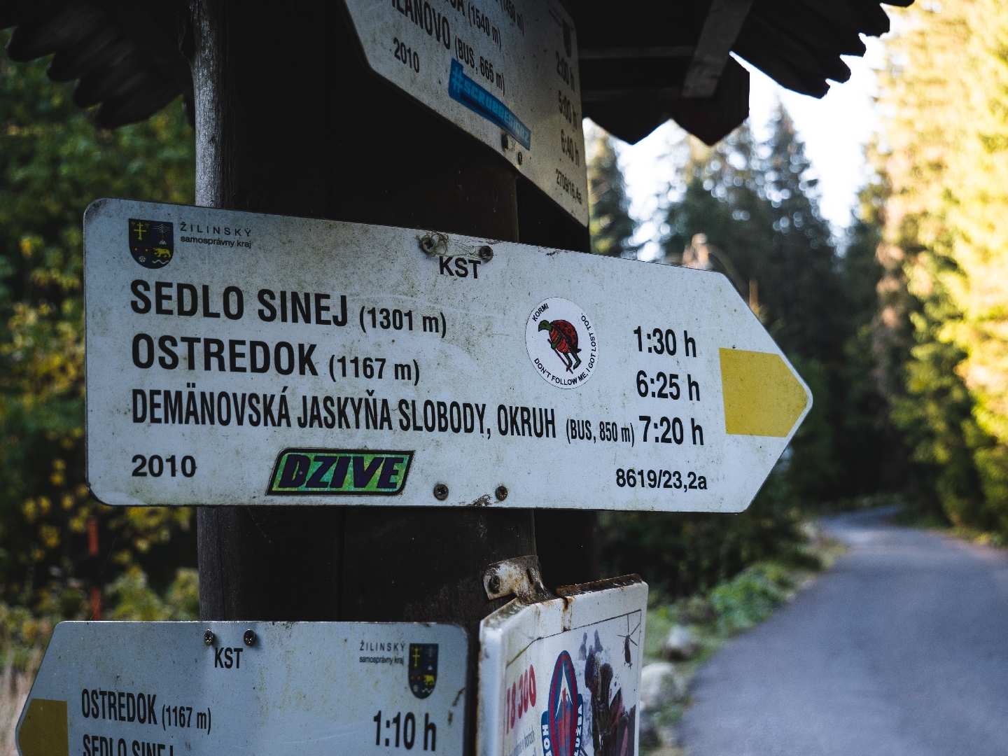
The route is not circular, so you need to use public or other transport. Park the car at the ATC Bystrina camping grounds located at the beginning of the village of Demänovská Dolina, near the turn off to the Pavčina Lehota village. Right at the turn off, there is a bus stop that will take you to the Demänovská jaskyňa slobody cave.
From there, follow the green trail markers down the valley alongside the Demänovka river.
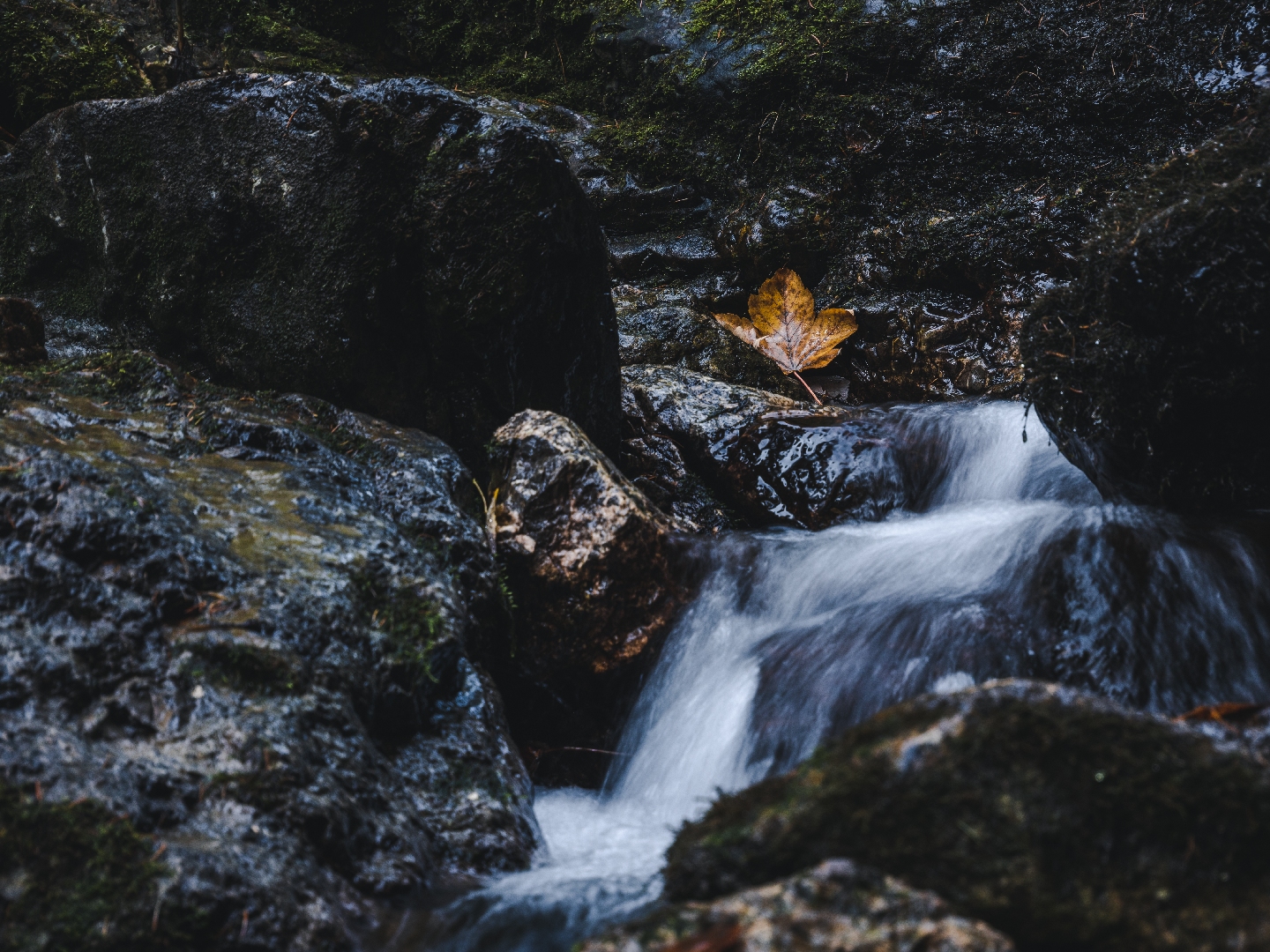
The route runs alongside a busy road leading to Jasná, but the road noise is minimal. Continue over small bridges to the confluence of the Demänovka river and a stream flowing from the Dolina Vyvieranie valley and welling up from the depths of the karst underground. After you enter the Dolina Vyvieranie valley, the trail will lead you along the bed of a stream which is not wide nor deep. Since the valley is a part of the National Nature Reserve, there are some fallen trees as well as trees that have been pruned in order not to block the trail along the way. The valley starts opening up in the middle part of the route. Later, the route gets quite steep and serpentine, taking you to the side of the valley and out of the woods. At one point, the trail crosses a creek with rock cascades. The part of the route leading from the Iľanovské sedlo mountain saddle to the bottom of the Demänovská hora mountain is flat.
It will take you along a quiet traversing path located just below the ridge. NAPANT (Low Tatras National Park) maintains the route, so the path is very comfortable. The landscape changes again and the scent of pine trees fills the air. At the western side of the Demänovská hora mountain, which is the last peak of the ridge, the path will lead you to a panoramic grassy and rocky terrace overlooking the Demänovská dolina valley, the Liptovská Mara dam, Liptovský Mikuláš and its surrounding.
The yellow trail markers will guide you to the crossroad from where it is possible to reach the Demänovská hora mountain as well. Continue towards ATC Bystrina instead. The ascent is steep but short, so most people can make the summit with no problems. The circular views you will get are glorious and definitely worth taking a short breather for. At the peak, you will find a small wooden cross and a visitors book for you to sign.
The descent is quite steep at the beginning but the trail serpentines make it easier. On the whole, the hike is very pleasant and not tiring. The route finishes at the ATC Bystrina camping grounds.
You can park the car at ATC Bystrina. The car park has sufficient capacity.
You can also get here by local bus. Bus timetables>>>
The villages of Pavčina Lehota and Demänovská dolina have a range of accommodation and dining options.
You can find and book your accommodation here.
From Hrabov, you can take an easy family walk from Hrabovská to the neighboring Čutkovská Valley along the Giant Road, passing giant glasses, giant crayons, a giant chair, giant binoculars and a giant slide along the way. The route will take you to the Obrovo Children’s Amusement Park. The route forms a connection between Hrabovská and Čutkovská Valleys, i.e. between the two most visited places in Ružomberok. It leads along a forest road, which only has an asphalt surface on a small part.
It is also passable on mountain and trekking bikes, not on road bikes. You need to be very careful on a bike, especially when descending towards Čutkovská Valley, and not take unnecessary risks. The route is not suitable for small children on bicycles, you need to have some experience in riding. For smaller children under 12 years of age, a walk is more suitable. The route is approximately 4.5 km long one way.
Along the Giant’s Path you will find things that the giant Čutko lost. At Čutkovo, the Obrovo area will entertain children and adults with a ride on the highest zipline in Slovakia. You can also eat well at ‘koliba Richtárka’. At Hrabovo you can relax or use the playground under the reservoir. If the country’s highest zipline was not enough, visit Tarzania, where this time you can enjoy the longest zipline in Slovakia.
Description of the route:
From the stop and parking area, we head towards the dam. On its right bank, there is the first artifact, a giant painting. We return above the dam to the road, where there is a cycling signpost “Hrabovo Water Reservoir”. From there, we take the yellow-marked cycle route to our destination in Čutkovska Valley. The route leads us past cottages and apartment houses. As another artifact, we can notice a “pin”. Later in the forest, “giant glasses”, “crayons” and a “chair”. At the chair, we are at the highest point of the route and then we will only go downhill. On the way, we will come across a “giant telescope”, a “giant spoon” and a “giant ring”. There are several turnings from the forest road along which the Giant’s Path leads, but it is enough to stick to the yellow cycling markings. There are also several Giant’s Path signposts on the route, which will guide us in the right direction.
When visiting the Giant’s Causeway, you can take advantage of numerous services and attractions in both valleys.
One of the places you should visit when wandering around the Liptov region is Liptovská Lúžna, a mountain village situated in the Low Tatras. If you are heading from the Liptovská Osada village, drive through the Liptovská Lúžna village in the direction of Železnô. The lookout tower offering wonderful view of the surrounding nature is located on the left hand side, app. 500 m after the village. You will reach it within a few minutes of easy walking. The path leads through a meadow and offers views of Lúžanské Meandre of the Lúžňanka stream with clear and slowly flowing water. The meanders – bends in the stream – were formed as the result of a sharp decrease in the stream’s slope, creating an optical illusion that the stream is flowing uphill.
The lookout tower does not fulfill the standard purpose of lookout towers, which are built on hills for the sake of a view. Its purpose is to make the unique natural monument of the Lúžňanka Meander visible. By looking from the lookout tower, the visitor of the meanders gains a better perspective and overview. From the lookout tower, the natural meandering of the Lúžňanka River is better visible and brings a much greater experience. The best time to visit this place is between March and May.
Entry to the lookout tower is at your own risk.
Description of the route:
From the stop, we head slightly uphill. There is also a red-marked cycle path along the road in our direction, which will serve as a guide. The road and cycling signs will lead us out of the village to the foothill meadows. Before the place where the road enters the forest, we leave the marked cycle path and turn left between wooden posts onto a gravel road. At this point, it is possible to park cars so that they do not obstruct other vehicles. The paved field road leads past a cattle shelter to a stream, where we learn from the information board that we are entering the Protection Zone of the Low Tatras National Park. After walking a few dozen meters, we can already see the lookout tower itself. By the stream in front of the lookout tower, there is another sign, from which we learn that the site is a natural monument. We climb up to the lookout tower via two steep wooden staircases and the meanders are at our fingertips.
Explore a short educational Trail of artists in the beautiful surroundings of the Lúčky Spa. It leads behind the Spa Hotel Choč, the Dependance Liptov spa house and the Balneocentrum. The trail is dedicated to the memory of famous artists whose lives were connected to Lúčky. The gazibo is dedicated to Milan Michal Harminc, a famous architect who designed the Dependance Liptov spa house. The artistic benches are dedicated to Tadeáš Salva, a famous composer who was born in Lúčky, and to Jožko Piťo, one of the most famous first violinists in Slovakia who used to play in Lúčky and who contributed to the promotion of Slovak folk music.
M. M. Harminc: was one of the most active Slovak architects. He was professionally active for 65 years ( 1886 – 1951 ) during which he designed over 300 buildings throughout Europe, of which 171 were situated in Slovakia. He was born on 7 October 1869 in Serbia. In 1886 he left for Budapest, where he worked for several construction companies. He founded his own construction office in 1897 and by the beginning of the war, he managed to design 45 houses. In 1915 he moved with his family to Slovakia, to the town of Liptovský Mikuláš, where he opened a design and construction office. What connects him to the Lúčky Spa is the building of the Liptov spa house he designed. The war postponed its opening to 1946 when it began operating with the capacity of 100 beds. He died in 1964 in Bratislava.
Dominik Ševc: He was born (March 12,1895), lived and was artistically active in Lúčky, the place he loved. He founded the Folklore Group Lúčan, originally called Choč (in 2020 it celebrated 80 years since its foundation). He sewed costumes for the group, choreographed the dances, composed folk wishes and songs, performed in an amateur theatre…He dedicated 60 years of his life to the promotion of cultural life of Lúčky, with the desire to preserve traditions and cultural heritage of our ancestors. Under his supervision, the ensemble rehearsed a hussar dance, a recruit dance, a stick dance and a so-called “šatôčkový” (handkerchief) dance as well as a traditional wedding performance, Priadky performance and an unforgettable Pltnica perfomance, the idea of which was taken over by SĽUK (Slovak Folk Art Ensemble). He was awarded the Folklore Festival Východná commemorative medal by the then Minister of Culture in 1973.
Jožko Piťo: He was born in 1800 in Tekovské Lúžany. After serving for 12 years in the Imperial Army, he got to Liptovský Mikuláš where he first encountered the Slovak folk song which had him captivated from then on until his death in 1886. He formed his own band which played for lords from all over Slovakia. That is how he got to the Lúčky Spa where he entertained guests during the spa season. His violin virtuosity was described by many Slovak poets and writers, yet the best description is believed to be given by S. H. Vajanský in his “Husľa” novel. Jožko Piťo helped raise Slovak national awareness by placing a folk song to the pedestal it rightfully deserves.
Andrej Plávka: A poet born to the family of a tanner in the village of Liptovská Sielnica in 1907. He worked as a director of the Tatran book publishing company from 1949 to 1968 and was a chairman of the Association of Slovak writers in the years from 1969 to 1982. He published his first poetic work in 1922 in the Nový rod magazine. He later published in the Mladé Slovensko, Svojeť, Mladé prúdy, Elán, Slovenské pohľady and other magazines. His work was inspired mainly by the older generations of Slovak authors, such as the Štúr group and mainly by P. O. Hviezdoslav. After L. Sielnica was flooded by the waters of the Liptovská Mara dam, the Lúčky spa became the place where he spent his holidays every year and where he sought inspiration for the many poems he wrote. He died in 1982 in Bratislava.
Tadeáš Salva: A music composer, associate professor and artist. This native of Lúčky (October 22, 1937) was musically gifted from a young age. He studied accordion, cello and piano at the Higher Music School in Žilina. He continued his compositional studies at the Academy of Performing Arts in Bratislava with A. Moyzes and J. Cikker and finished his studies in Poland. He worked as a head of the Music Department at the Czechoslovak Radio Košice, a music editor for the Music Editorial Board of the Czechoslovak Television in Bratislava, a dramaturg in SĽUK (Slovak Folk Art Ensemble), an associate professor at the Department of Music Education of the Faculty of Education in Nitra. He served as a chairman of the Association of Slovak Composers from 1991 to 1995. He died in 1995 in Bratislava and is buried in Lúčky.
The trail is a combination of forest paths forming 2 basic circuits:
- Circuit A: starts at the entrance information panel (1), continues past the gazibo (2) and the bench of A. Plávka (3). After it passes the AQUA-VITAL park, the trail leads out of the forest into the area of the Spa. From there it joins up with the main road and after passing the Spa Hotel Choč, it returns back to the entrance panel (1). The total length of the Circuit A is 1 310 m.
- Circuit B: starts at the entrance information panel (1), continues past the gazibo (2) and the bench of A. Plávka (3) to the crossroad (5). Then the trail takes you up in gentle serpentines to the bench of D.Ševc (8) and the Chapel of St Anton Paduánsky (9). From there, it is only a short walk to the top of the Holý kopec hill (10) where you will find the bench of Tadeáš Salva (11), offering great views of the Low Tatras in nice weather. The trail then takes you back down to the gazibo (2). The total length of the Circuit B is 1 350 m.
- You can extend the length of both circuits an extra 600 m by turning to a pleasant forest path (from points 4 or 5), leading to the bench of J. Piťo (6) and the local waterworks (7). In addition to the starting point 1 (entrance information panel), you can access the trails of both circuits from points 4, 7, 10.
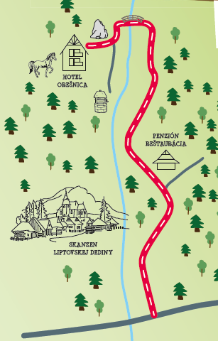
Pribylina – Račkova walley
- Route: 8 km (4 km and back)
- Marking: CTT blue 2436
- Surface: asphalt road
- Difficulty: slightly ascending
A mildly ascending trail leading alongside a museum to a forest railway exposition
The trail starts at the parking place adjacent to the open air museum in Pribylina. There is a buffet in front of the museum where you can get some refreshment. When continuing through the open air museum and head to the forest, you´ll get to the exposition of Považská forest railway. There you can see old trains and a train depot. Behind the depot the model flood protection dike is situated.
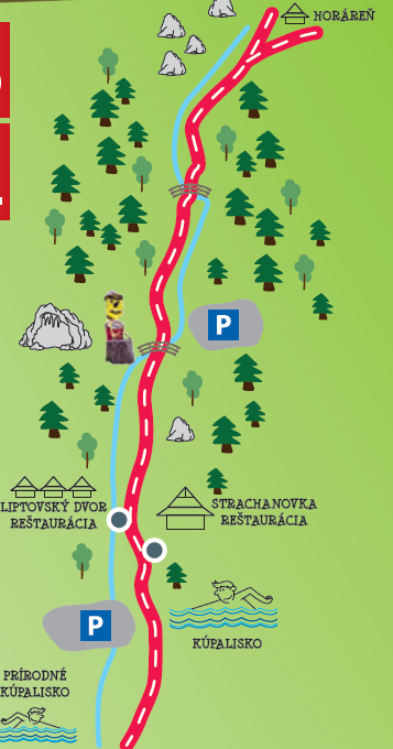
• Route: 7 km (3.5 km and back)
• Marking: green CTT 5462
• Surface: new asphalt road of excellent quality
• Difficulty: slight ascent
The car park by the summer open air pools is the starting point of the route for those who already know how to cycle even on roads with traffic. If you are just waiting for this stage of your children’s life, you don’t have to be sad. You can drive to the valley to the parking lot at Stanišovská Cave, from where the road continues along the river without cars. The base of the entire route is asphalt, in the end of lower quality. The slight ascents of the road are enriched by short descents and steeper ascents, which you will definitely manage.
The riding experience is enhanced by views of the side ridges of the Low Tatras, a rock window on the left side of the valley and the noise of a meandering river. A pleasant refreshment during hot days is a 60-minute journey with a headlamp and a guide through the bowels of the Stanišovská Cave, the success of which you can celebrate with traditional Liptov delicacies in the Strachanovka hut below on the route. Are you afraid of the dark? It doesn’t matter in Liptovský Ján either. At the cave, you can immortalize yourself with wooden figures or visit the lookout tower, which offers a beautiful view of the village and its surroundings.
Parking: parking by the summer swimming pool Termal Raj
• Route: 8 km (4 km and back)
• Marking: red CTT 033
• Surface: asphalt pavement, paved road
• Difficulty: moderately rising, almost horizontal
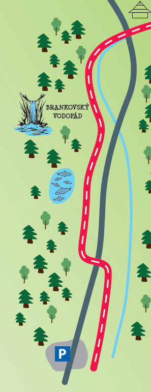
Description of the route: The section of the children’s route follows the route of CykloKorytnička, which leads mostly on the original railway route from Ružomberok to Korytnice and offers visitors the beauty and interestingness of the Revúcka Valley. From the parking lot in front of the Motel Vlčí dvor, the cycling trail leads through a separate cycle path outside the road. During the route you can enjoy the view on the sluices on the river Revúca, breeding ponds or turn to Brankovský waterfall (30 min walk). In the end, the surface of the route turns into a paved road that rarely passes through the foresters’ car. The route in two places crosses the first class road.
Parking: parking in front of Motel Vlci dvor
- Total route length: 8 km (4 km and back)
- Marking: yellow CTT 8418
- Surface: asphalt road
- Difficulty: a slightly ascending road with one steeper section
Route description: The route starts at a parking lot next to the Koliba u Dobrého Pastiera restaurant., where you can also find Obrovo, a unique world of the giant Čutko. From the lot, follow the yellow marked trail leading along a slightly ascending asphalt road with one steeper section. Along the route you will pass a lake where you can relax and also a playground where kids can play. You can quench your thirst at one of the several mountain springs with drinking water along the way. To satisfy your hunger, you can either use one of the fire pits to light a campfire and have a barbecue or you can go to the Koliba u Dobrého Pastiera restaurant where the chefs will be happy to cook for you. The route will also take you past feeding racks, a dam, a wide boar game preserve and a flock of sheep. If you still have some energy left at the end of the walk, you can walk to the Pálenický Vodopád waterfall (40 minutes on foot).
Parking options: in front of the Koliba u Dobrého Pastiera restaurant
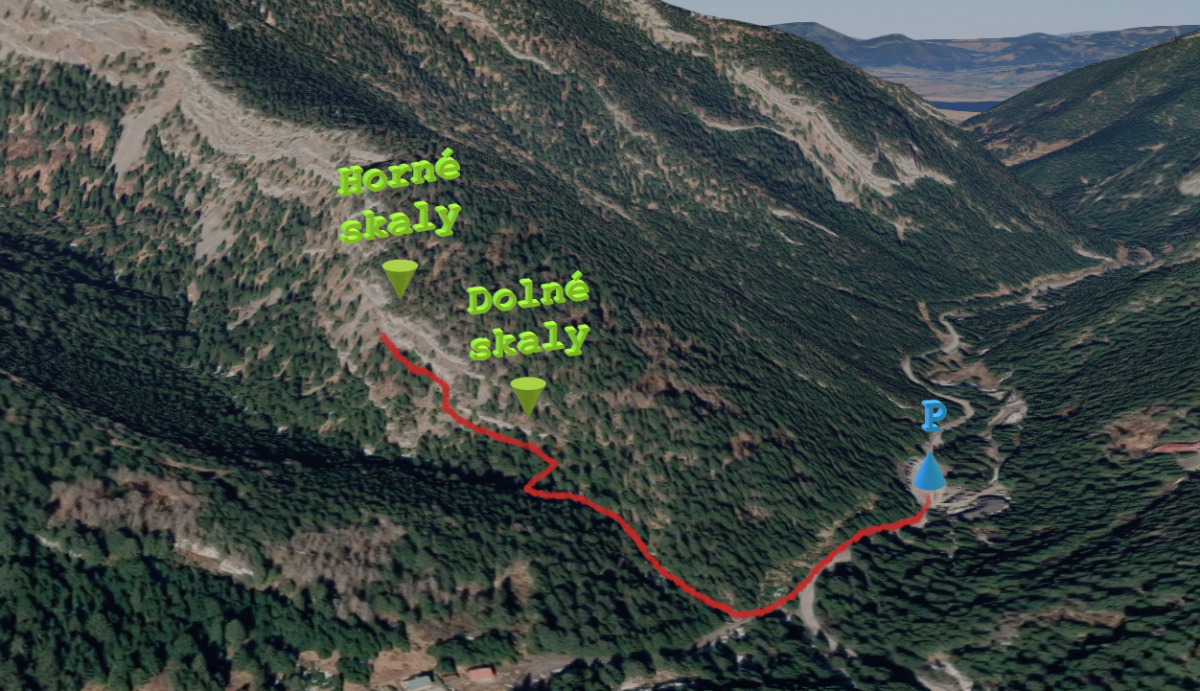
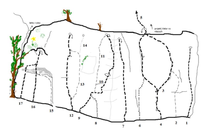
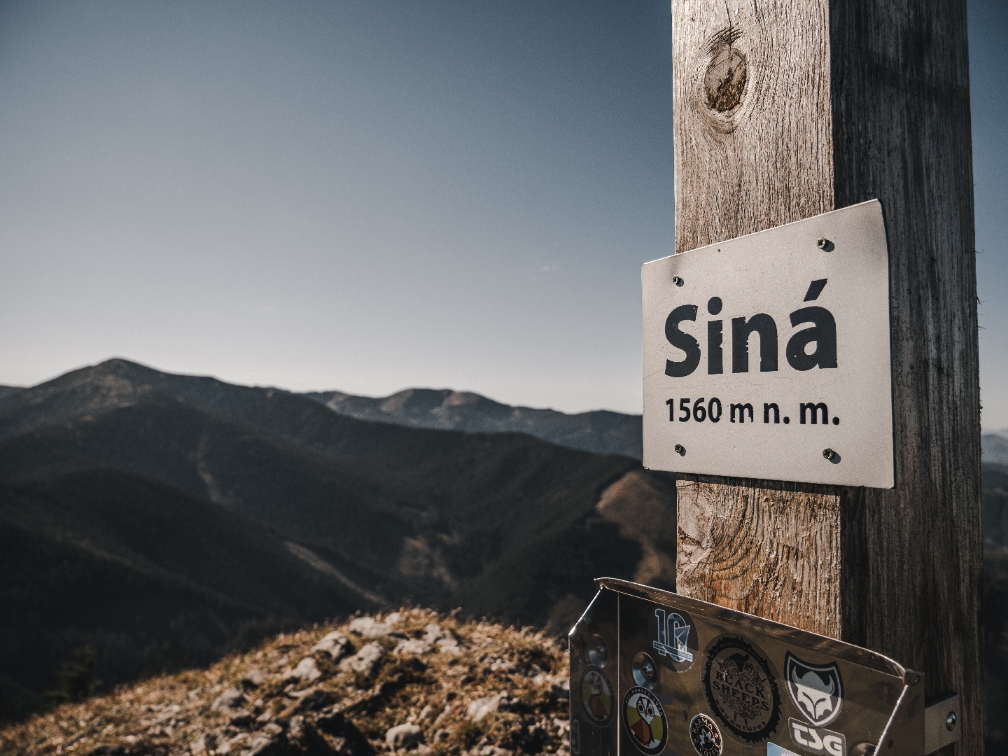
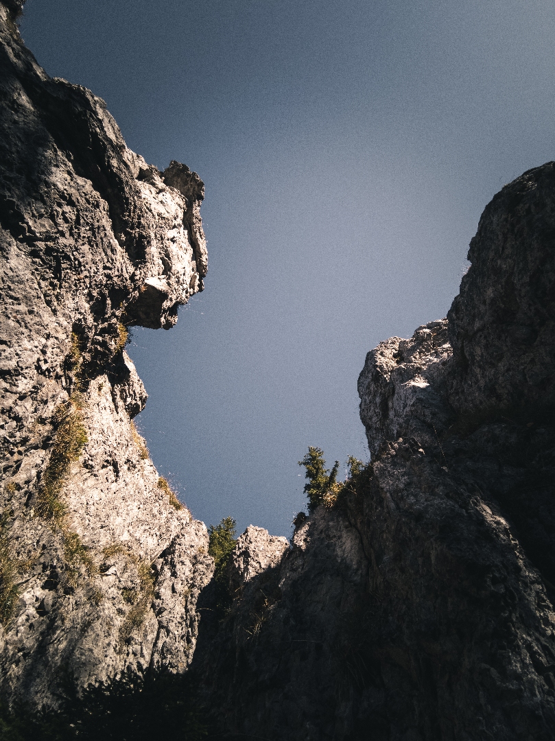
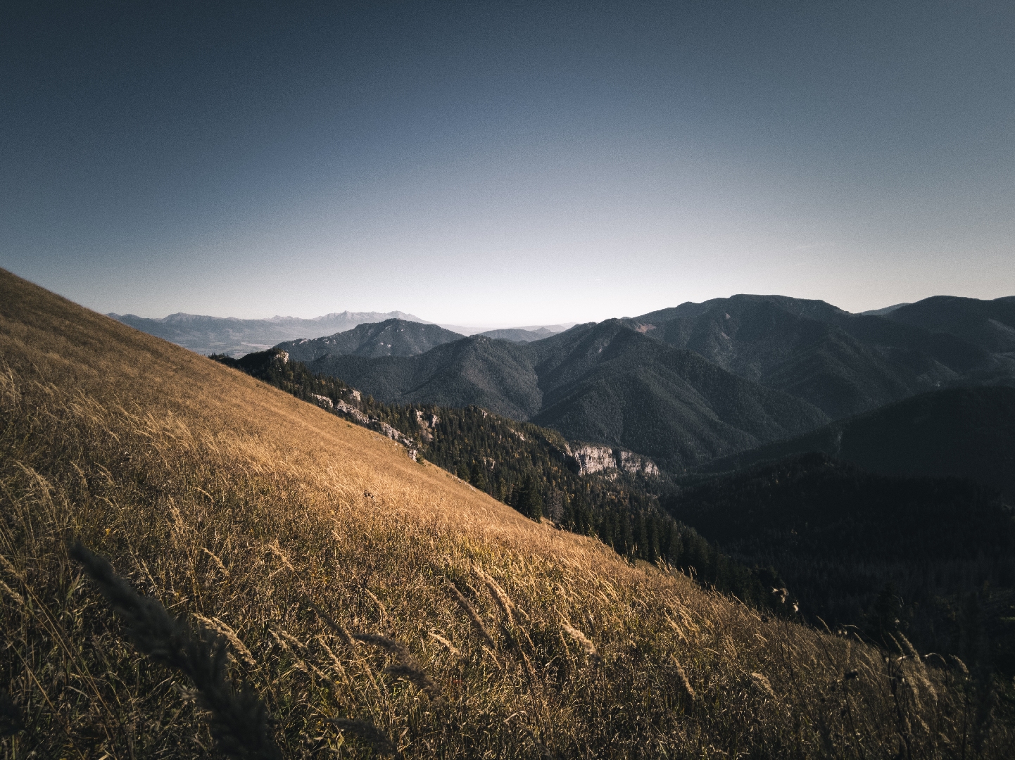
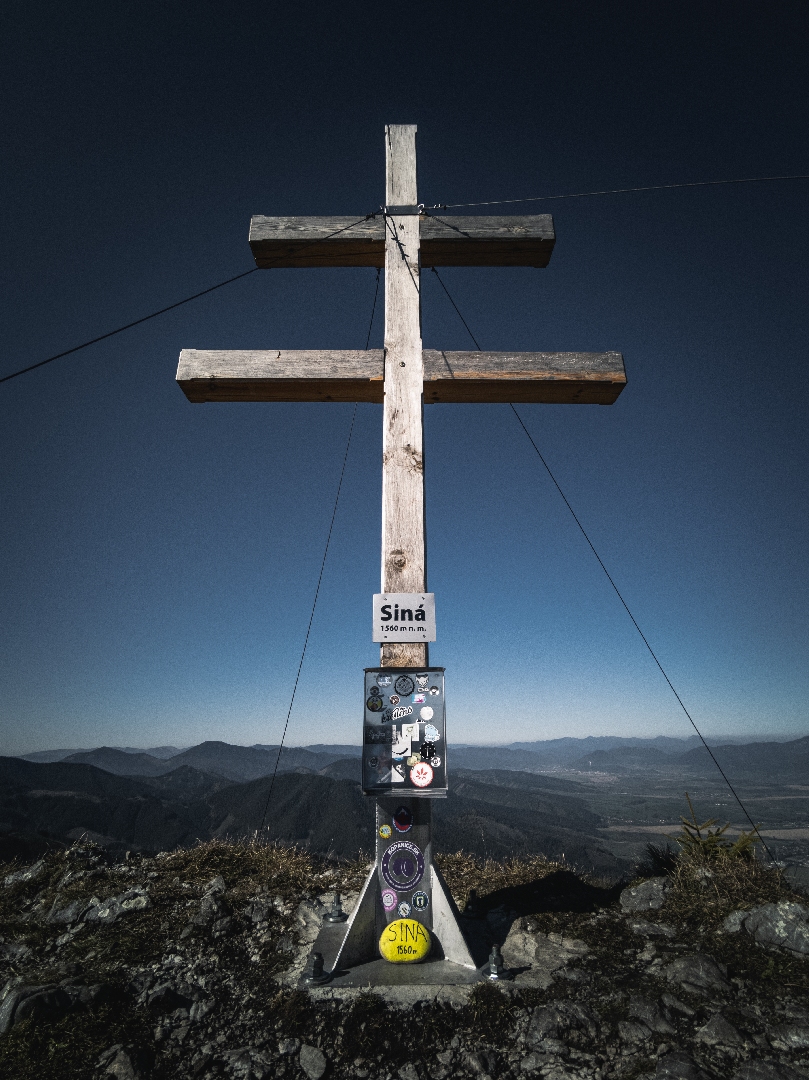
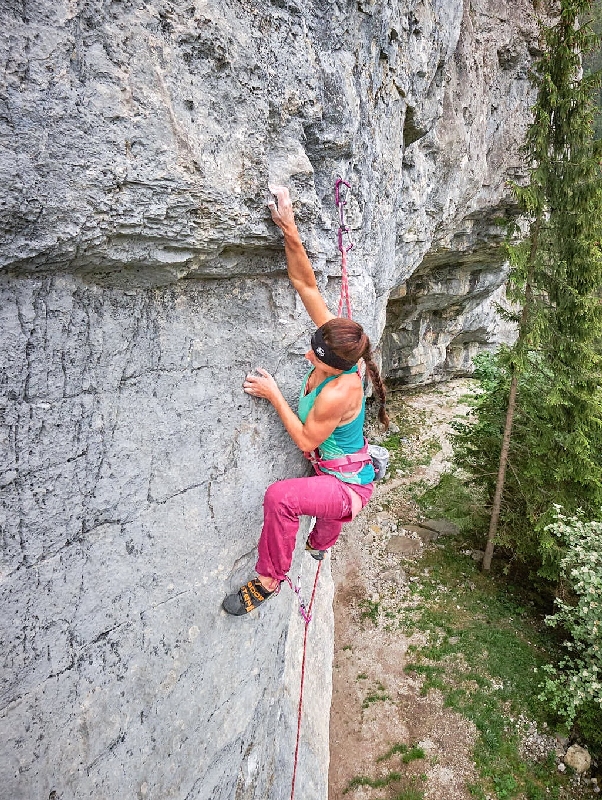
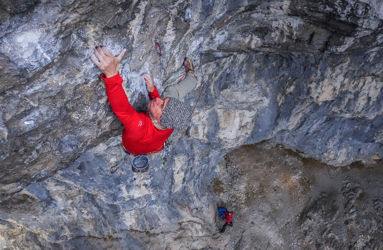
Probably the most beautiful part of the Demänovská valley consisting of a limestone massif which stretches from the mouth of the valley to the half of the Siná mountain. Climbing is permitted only in the bottom part of the mountain, from May 1 to Febuary 28. The bottom part is divided into Horné and Dolné skaly. The exception is valid until 2022 but we believe that it will be extended.
Climbing here is very unique and special. The rock is solid and has many faces, so the climbs here are technical and endurance demanding. Most of the holds are small. More than 100 routes vary in difficulty, ranging from VI+ to X+ UIAA, with most of them having the difficulty level of about VIII. It is, however, important to remember that the routes are half a degree more difficult than the routes in the other climbing areas. The whole massif faces south, so the rock is hot in summer. With the exception of the bottom cave, the whole area is ideal for climbing on cold days. Because of the features of the rock, the whole area best suits experienced climbers who will not regret visiting Siná.
Climbing permitted: 1.5. – 28. 2., the exception is valid until 2022
Info james.sk: List of climbing areas in Slovakia, restrictions, rocks wardens
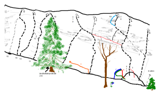
Sector: Horné skaly
No. of routes: 70+
Difficulty: VI+ – X+ UIAA
Length of routes: 15 – 33! m
Approach: 10 min.
Take the Demänovská dolina exit from the D1 highway and continue to the parking lot in front of the Demänovská Cave of Liberty (Demänovská jaskyňa slobody). Then follow the yellow footpath markers on a path leading to the top of Siná. Enter the valley and walk past a meandering creek. After about 200 metres leave the footpath to Siná and turn right to the footpath that will take you right beneath the rocks. From here you will see a row of rocks which you will reach easily in about 5 minutes.
Description: 12 glue-in stainless steel bolts + abseil chain.
Probably the most beautiful route in Horné skaly. The challenge is a boulder at the beginning of the route, under the first anchor. That is why it is better to fix the first anchor to the ground. The route then continues onto a slightly steep face with good holds, allowing you to move as if you were dancing.
See www.shsjames.org for current restrictions.


Probably the most beautiful part of the Demänovská valley consisting of a limestone massif which stretches from the mouth of the valley to the half of the Siná mountain. Climbing is permitted only in the bottom part of the mountain, from May 1 to Febuary 28. The bottom part is divided into Horné and Dolné skaly. The exception is valid until 2022 but we believe that it will be extended.
Climbing here is very unique and special. The rock is solid and has many faces, so the climbs here are technical and endurance demanding. Most of the holds are small. More than 100 routes vary in difficulty, ranging from VI+ to X+ UIAA, with most of them having the difficulty level of about VIII. It is, however, important to remember that the routes are half a degree more difficult than the routes in the other climbing areas. The whole massif faces south, so the rock is hot in summer. With the exception of the bottom cave, the whole area is ideal for climbing on cold days. Because of the features of the rock, the whole area best suits experienced climbers who will not regret visiting Siná.
Climbing permitted: 1.5. – 28. 2., the exception is valid until 2022
Info james.sk: List of climbing areas in Slovakia, restrictions, rocks wardens
Sector: Dolné skaly
No. of routes: 35
Difficulty: VI+ – X UIAA
Length of routes: 10 – 12 m
Approach: 10 min.
Take the Demänovská dolina exit from the D1 highway and continue to the parking lot in front of the Demänovská Cave of Liberty (Demänovská jaskyňa slobody). Then follow the yellow footpath markers on a path leading to the top of Siná. Enter the valley and walk past a meandering creek. After about 200 metres leave the footpath to Siná and turn right to the footpath that will take you right beneath the rocks. From here you will see a row of rocks which you will reach easily in about 5 minutes.
Description: 7 glue-in stainless steel bolts + abseil chain.
One of a few warm-up routes Siná has. It leads through a distinctive block with good holds ideal for using piaz moves. The climb to the “balcony” is a bit of a challenge but the final moves are on good holds through an overhanging rock.
See www.shsjames.org for current restrictions.

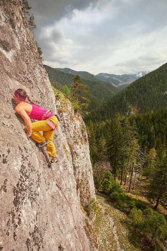
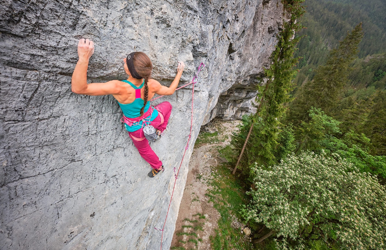
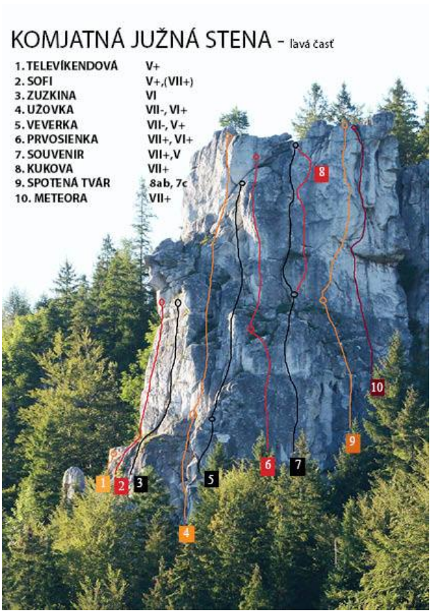
The newest climbing area in Liptov consisting of a 50-metre-high conglomerate rock. It towers over the boundary of the Studničná and Komjatná villages, in the municipality of Ružomberok. It hosts beautiful climbing routes for climbers of different levels and offers an opportunity to climb long routes. An amazing feature of conglomerate rock is that it has many holds, scales and notches, which is why the area is the top rock climbing destination in Liptov. The view from the top of the rock is one of the most beautiful in the region.
Climbing permitted: all year round
Info james.sk: List of climbing areas in Slovakia, restrictions, rocks wardens
No. of routes: 35
Difficulty: V – X- UIAA
Length of routes: 20 – 45! m
Approach: 15 min.
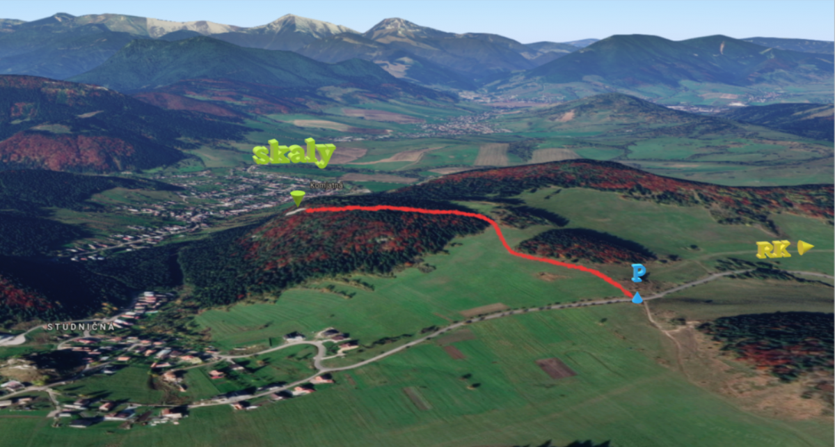
Take the road leading from Ružomberok towards Dolný Kubín. At Komjatná turn right and carry on for about 2 km up the hill. You will see Studničná – part of the Komjatná village – from there. Park the car on the hill, right next to the chapel that stands next to the road. Then take the field path towards Komjatná. Cross the meadow and walk the steep short hill that will lead you to the forest. Turn left to the forest and follow the footpath. It will take you 5 minutes to get to the top of the reef. There is a path on both sides of the reef leading down under the rocks.
Description: 15 glue-in stainless steel bolts + abseil chain.
One of the best routes in Komjatná. It starts with a 10-metre long corner that leads to a rest shelf. It then continues with a rounded edge over which you will get to the final face. The route is airy and will test your endurance.
See www.shsjames.org for current restrictions.
The newest climbing area in Liptov consisting of a 50-metre-high conglomerate rock. It towers over the boundary of the Studničná and Komjatná villages, in the municipality of Ružomberok. It hosts beautiful climbing routes for climbers of different levels and offers an opportunity to climb long routes. An amazing feature of conglomerate rock is that it has many holds, scales and notches, which is why the area is the top rock climbing destination in Liptov. The view from the top of the rock is one of the most beautiful in the region.
Climbing permitted: all year round
Info james.sk: List of climbing areas in Slovakia, restrictions, rocks wardens
No. of routes: 35
Difficulty: V – X- UIAA
Length of routes: 20 – 45! m
Approach: 15 min.
Take the road leading from Ružomberok towards Dolný Kubín. At Komjatná turn right and carry on for about 2 km up the hill. You will see Studničná – part of the Komjatná village – from there. Park the car on the hill, right next to the chapel that stands next to the road. Then take the field path towards Komjatná. Cross the meadow and walk the steep short hill that will lead you to the forest. Turn left to the forest and follow the footpath. It will take you 5 minutes to get to the top of the reef. There is a path on both sides of the reef leading down under the rocks.
Description: 11 glue-in stainless steel bolts + abseil chain.
A nice route for getting acquainted with the area. It finishes with a comfortable stance from where you can climb the route called Zuzkina, which has the difficulty level of VI. Take a long enough rope! The route is named after the Televíkend TV show in which the route was climbed.
See www.shsjames.org for current restrictions.
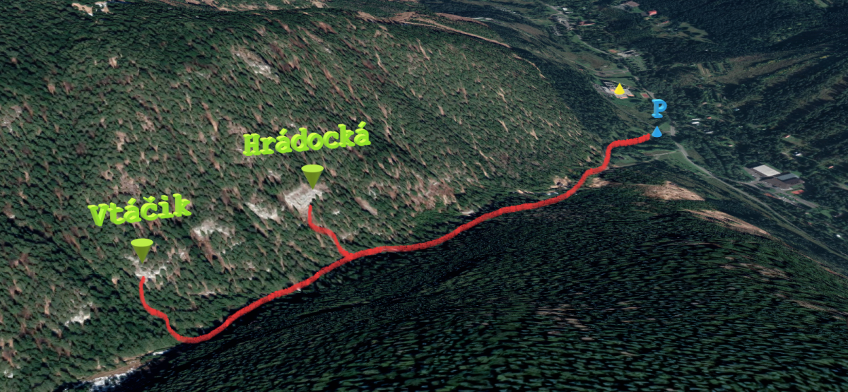
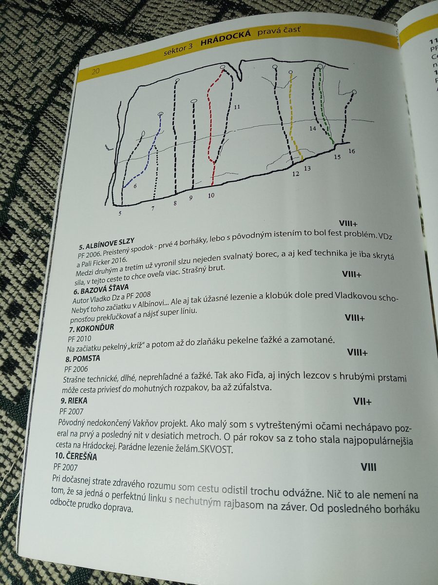
A nice quiet area hidden in the woods of the Biela dolinka behind the Liptovský Ján village. It comprises several limestone reefs that are divided into four main sectors. It is suitable for beginner as well as experienced climbers who favour technical routes. The big advantage is that climbing is allowed all year round and so you can spend nice time here on warm winter days.
The routes vary in difficulty, ranging from IV to IX+ UIAA, with most of them having the difficulty level of around VI and VII. The routes are technical and the longer ones are also strenuous, requiring a great deal of endurance.
Climbing permitted: 1. 8. – 31. 1., a od 1. 2. – 31. 7.
Info james.sk: List of climbing areas in Slovakia, restrictions, rocks wardens
Sector: Hrádocká
No. of routes: 16
Difficulty: V – IX UIAA
Length of routes: 10 – 33! m
Approach: 15 min.
Take the Liptovský Ján exit from the D1 highway, drive through the village and into the Jánska valley. Pass the thermal swimming pool and the Strachanovka hotel and restaurant. Continue past the Bystrá hotel (on your right) and take the first right. Park your car in the parking lot next to a waterworks building and then walk the valley past the creek for about 10 minutes. At the point where the forest footpath crosses the creek keep to the right and walk the path uphill to the rocks (5 minutes).
Description: 12 glue-in stainless steel bolts + abseil chain.
A beautiful long endurance route that will challenge your finger strength at the beginning and test your endurance at the end.
See www.shsjames.org for current restrictions.
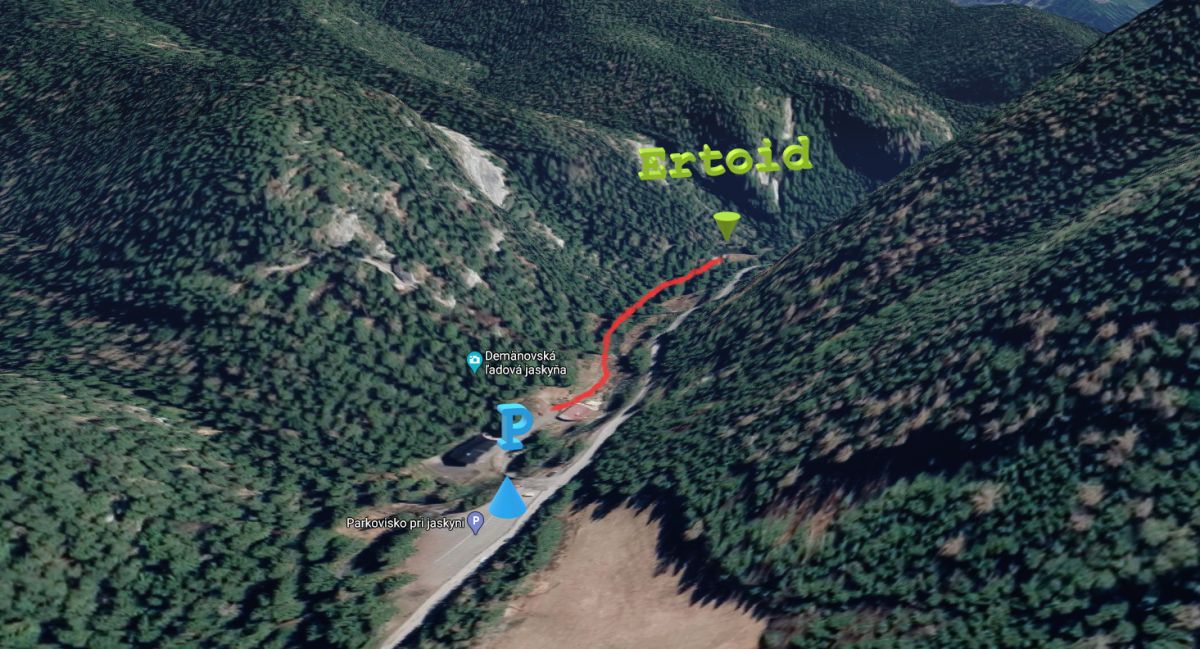
Newly established drytooling area in the Demänovská valley. Drytooling is a form of rock climbing in which ice axes and crampons are used to climb rock. Instead of using hands to rock climb, the climber hooks ice axes onto holds and pockets. Climbing Ertoid requires a lot of power and endurance. The climbing area consists of a wide limestone overhang which is only about ten metres high but it is very steep, with a short roof on its top.
Climbing here is permitted all year round. The wide overhang protects against rain but when there are heavy rains, water runs down over it. There are quickdraws clipped to the bolts during the winter months but they are removed in summer.
Form: drytooling
Climbing permitted: all year round, the exception is valid until 2022
Info james.sk: List of climbing areas in Slovakia, restrictions, rocks wardens
No. of routes: 22
Difficulty: D5+ – D12
Length of routes: 5 – 15 m
Prístup: 5 min.
Approach: 5 min.
Take the Demänovská dolina exit from the D1 highway and continue to the parking lot in front of the Demänovská Ice Cave (Demänovská ľadová jaskyňa). From there walk the asphalt road past the RiverSide hotel and then take the footpath on the left side of the creek. It will take you 5 minutes to get to a high distinctive wide overhang with quickdraws.
Description: 12 stainless steel rivets + abseil chain.
An endurance route with long reaches through good pockets. The route is fairly predictable and tall climbers have an advantage.
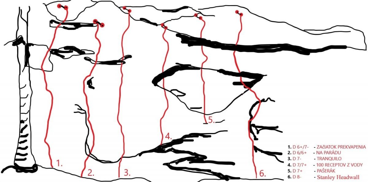
Foto: Marek Černý
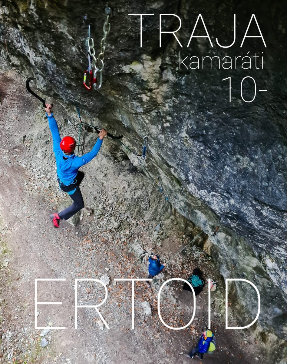
Foto: Igor Pap
See www.shsjames.org for current restrictions.
Newly established drytooling area in the Demänovská valley. Drytooling is a form of rock climbing in which ice axes and crampons are used to climb rock. Instead of using hands to rock climb, the climber hooks ice axes onto holds and pockets. Climbing Ertoid requires a lot of power and endurance. The climbing area consists of a wide limestone overhang which is only about ten metres high but it is very steep, with a short roof on its top.
Climbing here is permitted all year round. The wide overhang protects against rain but when there are heavy rains, water runs down over it. There are quickdraws clipped to the bolts during the winter months but they are removed in summer.
Form: drytooling
Climbing permitted: all year round, the exception is valid until 2022
Info james.sk: List of climbing areas in Slovakia, restrictions, rocks wardens
No. of routes: 22
Difficulty: D5+ – D12
Length of routes: 5 – 15 m
Approach: 5 min.
Take the Demänovská dolina exit from the D1 highway and continue to the parking lot in front of the Demänovská Ice Cave (Demänovská ľadová jaskyňa). From there walk the asphalt road past the RiverSide hotel and then take the footpath on the left side of the creek. It will take you 5 minutes to get to a high distinctive wide overhang with quickdraws.
Description: 5 stainless steel rivets + abseil chain.
The easiest route ideal for getting acquainted with drytooling. There are deep pockets in a steep rock wall. SUE and the neighbouring route Snaživec are suitable for warm-up climbs.
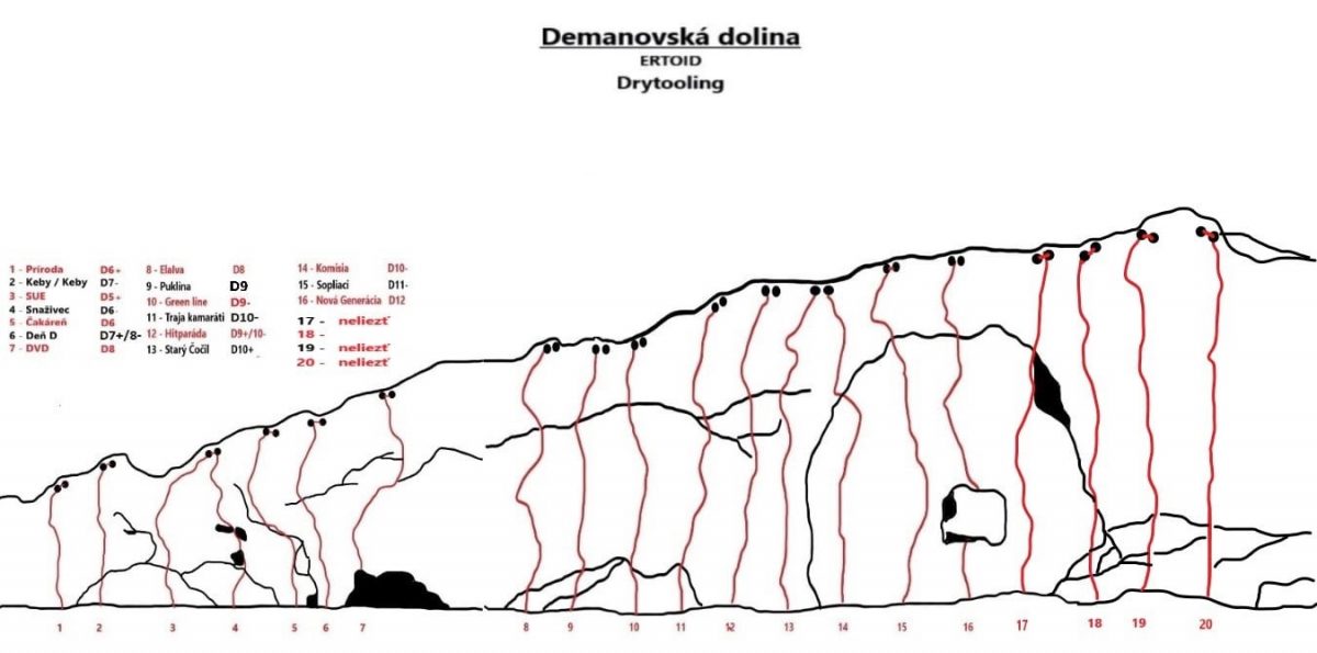
Foto: Marek Černý
See www.shsjames.org for current restrictions.
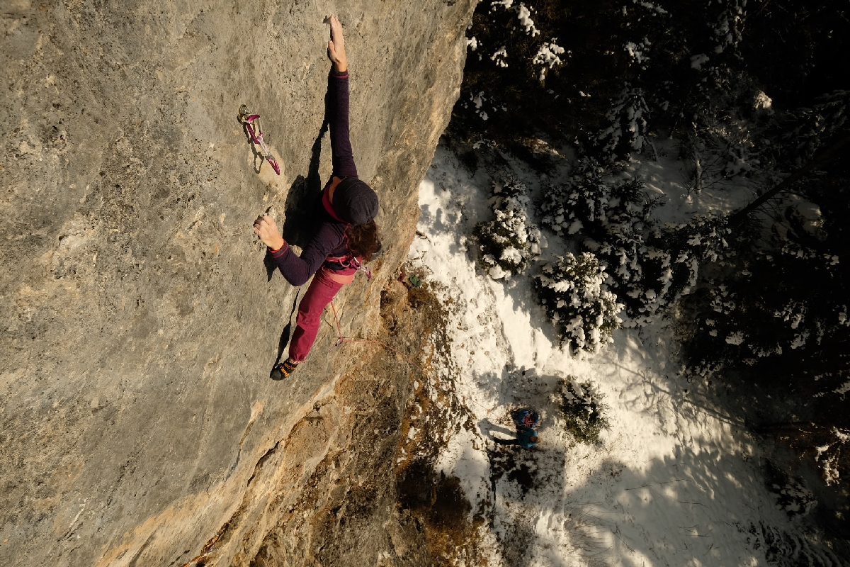
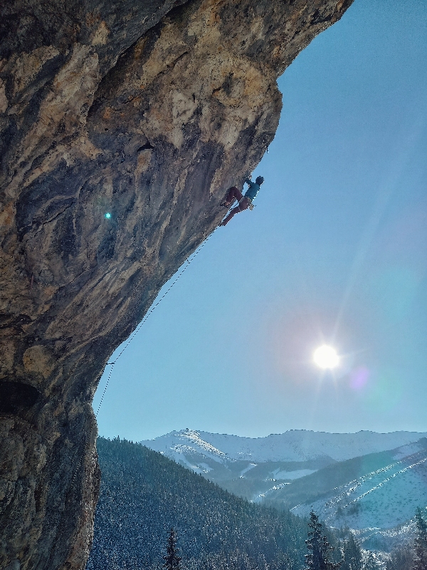
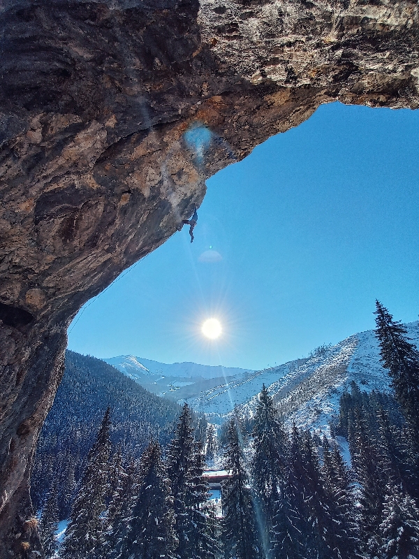
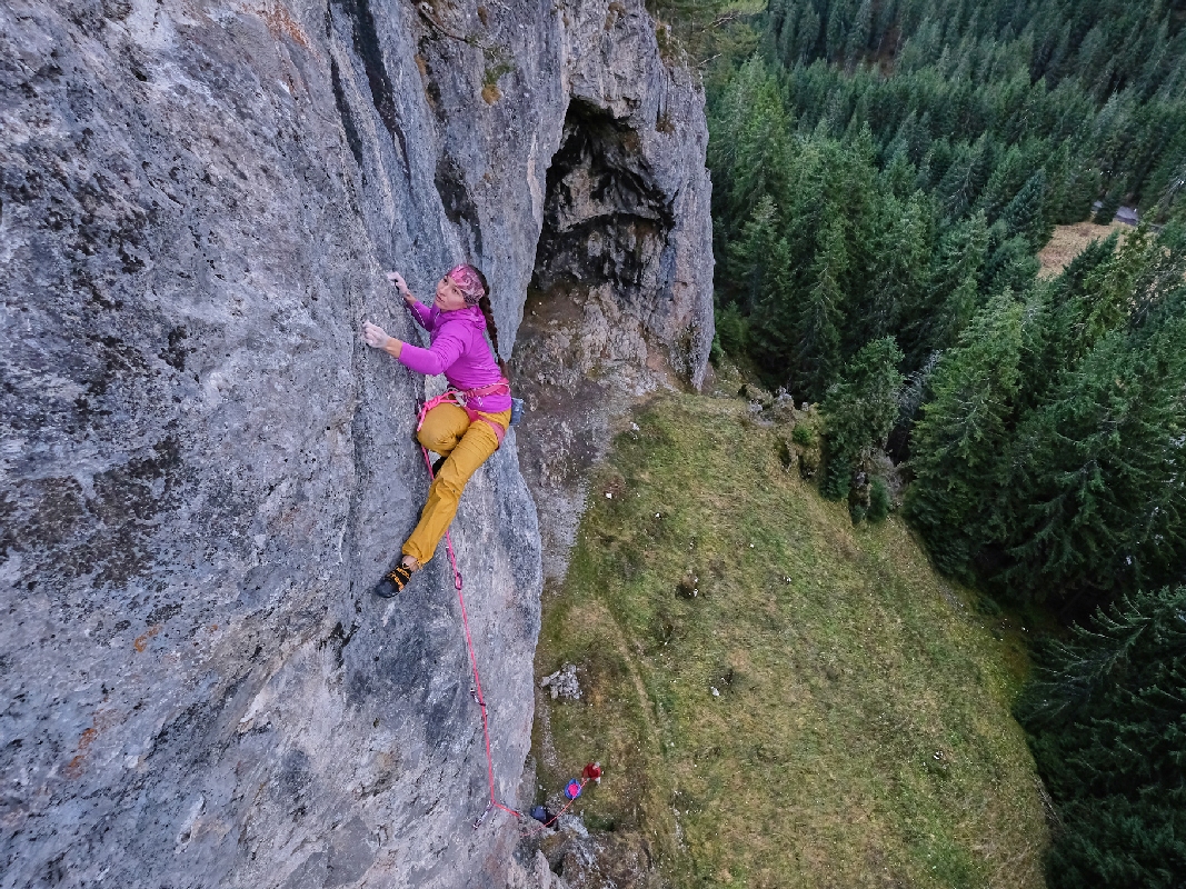
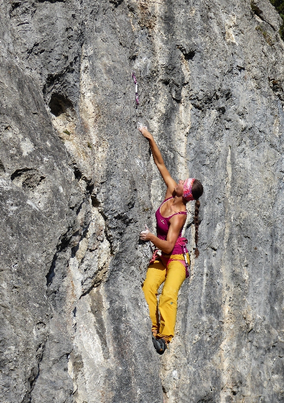
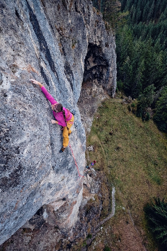
Probably the most difficult climbing area in the Demänovská valley consisting of a limestone arch soaring over the Repiská hotel. It comprises three distinctive arches and a technical face situated in the right lower part. Climbing here is permitted all year round but it is good to check it on www.james.sk.
The area offers power and endurance climbing. The rock is relatively solid and most of the routes lead to a distinctive overhang. There are more than 50 climbing routes ranging in difficulty from V+ to X+ UIAA, with most of them having the difficulty level of around VII. As the whole massif faces south, the rock is hot in summer, especially the arch which is even a bit hotter. That is why it is better to climb it in winter and autumn, or in rainy weather. It is ideal for strong sport climbers who want to push their limits.
Climbing permitted: all year round, the exception is valid until 2022
Info james.sk: List of climbing areas in Slovakia, restrictions, rocks wardens
GPS coordinates of the parking lot: 48.99849, 19.58290
GPS coordinates of the arch: 48.99134, 19.57648
- No. of routes: 50
- Difficulty: V+ – X+ UIAA
- Length of routes: 10 – 33! m
Approach: 15 min.
Take the Demänovská dolina exit from the D1 highway and continue to the parking lot in front of the Demänovská Cave of Liberty (Demänovská jaskyňa slobody). Then walk the asphalt road to the Repiská hotel (15 min.). There is an arch towering above the hotel. From there you can either continue walking the asphalt road or use a steep footpath that will take you directly to the arch. The footpath is located next to the retaining wall of the hotel.
Description: 19 stainless steel rivets + abseil chain.
Quickdraws.
The route best reflects the character of the climbing area. After a series of pulls and side pulls, the route starts on a technical face and it follows through a distinctive cave where you can rest. It then leads through a difficult overhang, almost a roof, and above the edge of the arch. Series of moves on two- and three-finger pockets.
See www.shsjames.org for current restrictions.

Probably the most difficult climbing area in the Demänovská valley consisting of a limestone arch soaring over the Repiská hotel. It comprises three distinctive arches and a technical face situated in the right lower part. Climbing here is permitted all year round but it is good to check it on www.james.sk.
The area offers power and endurance climbing. The rock is relatively solid and most of the routes lead to a distinctive overhang. There are more than 50 climbing routes ranging in difficulty from V+ to X+ UIAA, with most of them having the difficulty level of around VII. As the whole massif faces south, the rock is hot in summer, especially the arch which is even a bit hotter. That is why it is better to climb it in winter and autumn, or in rainy weather. It is ideal for strong sport climbers who want to push their limits.
Climbing permitted: all year round, the exception is valid until 2022
Info james.sk: List of climbing areas in Slovakia, restrictions, rocks wardens
No. of routes: 50
Difficulty: V+ – X+ UIAA
Length of routes: 10 – 33 m
Approach: 15 min.
Take the Demänovská dolina exit from the D1 highway and continue to the parking lot in front of the Demänovská Cave of Liberty (Demänovská jaskyňa slobody). Then walk the asphalt road to the Repiská hotel (15 min.). There is an arch towering above the hotel. From there you can either continue walking the asphalt road or use a steep footpath that will take you directly to the arch. The footpath is located next to the retaining wall of the hotel.
Description: 13 stainless steel rivets + abseil chain.
Beautiful distinctive pillar formation located in the right part, dividing the biggest arch and the lower wall. A long route up a slightly steep pillar that gets steeper close to its top. The middle part leads through natural pockets that will challenge your technique and strength.
See www.shsjames.org for current restrictions.


A nice quiet area hidden in the woods of the Biela dolinka behind the Liptovský Ján village. It comprises several limestone reefs that are divided into four main sectors. It is suitable for beginner as well as experienced climbers who favour technical routes. The big advantage is that climbing is allowed all year round and so you can spend nice time here on warm winter days.
The routes vary in difficulty, ranging from IV to IX+ UIAA, with most of them having the difficulty level of around VI and VII. The routes are technical and the longer ones are also strenuous, requiring a great deal of endurance.
Climbing permitted: 1. 8. – 31. 1., a od 1. 2. – 31. 7.
Info james.sk: List of climbing areas in Slovakia, restrictions, rocks wardens
Sector: Vtáčik – City center
No. of routes: 21
Difficulty: IV – VII UIAA
Length of routes: 8 – 12 m
Approach: 15 min.
Take the Liptovský Ján exit from the D1 highway, drive through the village and into the Jánska valley. Pass the thermal swimming pool and the Strachanovka hotel and restaurant. Continue past the Bystrá hotel (on your right) and take the first right. Park your car in the parking lot next to a waterworks building and then walk the valley past the creek for about 10 minutes. At the point where the forest footpath crosses the creek keep to the right and walk the path uphill to the rocks (5 minutes).
Description: 5 glue-in stainless steel bolts + abseil chain.
Nice and easy route ideal for beginner climbers to make their first contact with the rock.
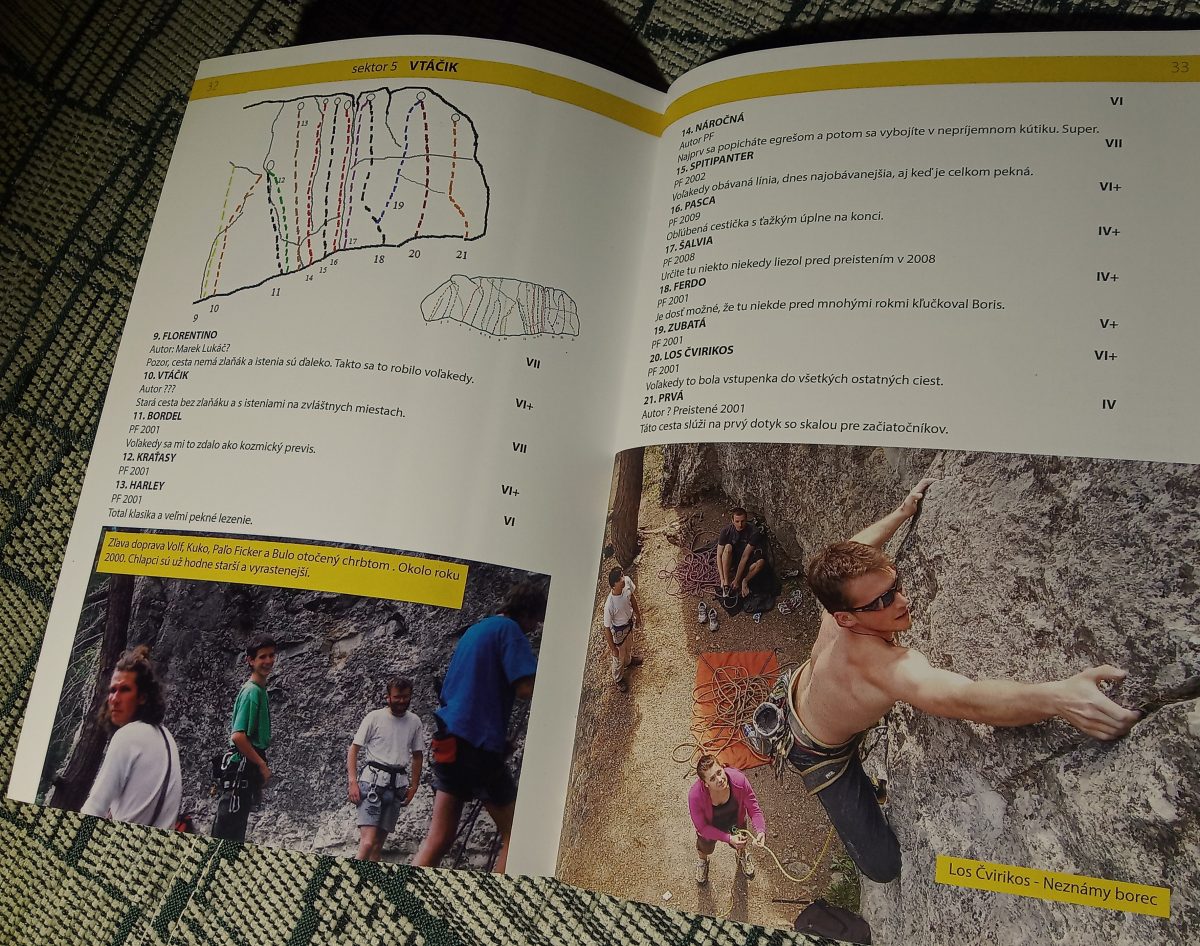
GPS súradnice Vtáčik: 49.02251, 19.65695
See www.shsjames.org for current restrictions.
A mining trail has been opened to the public in the Ľupčianska valley. There are 11 panels along an 8.4-kilometre-long circuit trail marked blue and then yellow.
The trail is a part of the “Slovak mining route” project, which connect educational mining trails in Slovakia. As you walk, you will learn more about the mining industry, gold mining, antimony ore processing, rock processing as well as about wild nature.
The author of the texts on the information panels is Martin Chovan, professor emeritus of the Faculty of Natural Sciences of the Comenius University in Bratislava.
Trail type
one-way, self-guided, year-round
Outdoor learning activities for schools
suitable for field trips and nature walks
The construction of the trail was initiated and organized by members of the Friends of Magurka Civic Association and the Magurka Chalet, who seek to revive the traditions and history of the area.
0. Magurka educational trail / placer gold mines, invitation to Magurka
1.Magurka chalet /educational trail map, brief history of mining
2. Village centre / settlement, ore dressing plant, church, ore treatment
3. Bašovňa, Bašovňa water circuit / leats, water reservoir, Russegger adit
4. Klinčok,Kilian adit /adits of Magurka, gold, sitting area. Map of adits
5. František adit. Forest management / Forest Compossessorate, Land Community in Partizánska Ľupča
6. Leopold adit / geology, minerals, Kapustisko, geological map
7. Ritterstein adit /Kapustisko-Močidlo mining section, water conduit, sitting area
8. Low Tatras National Park(NAPANT)
9. Striebornica /silver vein, mineral wealth of the Low Tatras
10. Viedenka / Viedenka, eastern part of the deposit, Mária adits, opportunity of trying gold panning
Golden trail of Magurka route description
Start from the Magurka Chalet and ascend on a pleasant and relatively undemanding blue trail that will take you to the ridge of the Low Tatras. From there follow the yellow trail back to to the Magurka Chalet.

Important
- The trail is located in the Low Tatras National Park, the area having the 3rd and higher degrees of protection. Please observe the code of conduct for the visitors to NAPANT
- The trail is for hikers only
On the border of the neighbouring villages Smrečany – Žiar, on the left side of the main road, there is a football field with a large parking lot. Here we recommend starting the route and connecting to an easily accessible field road leading beyond the barns of the village Žiar. At the peasant cooperative at the field junction, you continue to the right. The road continues for about one more km along the gardens belonging to the houses and continues through the meadow overlooking the Western Tatras and the dominant peak Baranec.
The meadow path leads to the Wild Boar pen area, which is located among the trees. It is not marked with any sign, so we indicate as a clue the last house in the village Žiar, which you have on the right side about 400 m from you. At this point, the road splits again, you continue straight, towards the north. You continue for a while through the meadow until you see, after a few meters on the left, a small bridge over the brook. Walk over the bridge directly to the game park.
The route is suitable for the beginners but also for families with children who want to spend their free time in the meadows in the Liptov region nature.
The village of Smrečany is located 7 km from the town centre Liptovský Mikuláš and is easily accessible by bus line LM – Žiar or by car. It is possible to park a car in front of the shopping centre Jednota, and there is also a bus stop nearby. 10 km circuit ideal for Nordic walking begins in front of the shopping centre.
It is a circuit, so the starting point is identical to the place of finish of the route, during which you will get beautiful panoramic views of the mountain ranges the Western and the Low Tatras, the Choč hills. In case of good visibility in the distance you will also see the transmitter Kráľová Hoľa. The most remarkable landmark of the route will be the magical view of the most famous Slovak peak Kriváň.
From the grocery shop Jednota in the village Smrečany, you will go about 100 m north along the main road, where at the first possible turn on the right turn right and continue along the road for another 300 m between the houses. You will pass Matej’s log cabin, and here you can make your first stop. Behind the cabin there is a giant area for fallow-deers, sheep, and a goat with baby goats. Behind Matej’s log cabin, you can finally get above the village and to the road between the fields. Approximately after the first kilometre from the grocery shop Jednota, you will pass by the crossroads of the villages Smrečany – Žiar.
It is a crossroad to all four world sides. You continue straight east to the village Veterná Poruba. At the cooperative Veterná Poruba, you do not turn into the village, but in the direction out above the village. You will pass the cooperative first, after a few meters further the cemetery, and on the way, you continue northwards further direction behind the village. On the fifth km of the start, on the left side there is the extinct settlement of St. Stephen and on the right, there is the sign NOVINY and new route towards the village Liptovský Ondrej. But you continue straight north and at the first possible turn on the left turn left and continue the asphalt road above the village Žiar. You will pass a 100-year-old apple tree growing in a field and later through a birch alley above the village Žiar. Here you have two options: Option number 1: Continue down to the village and walk through the village towards your car, or Option number 2: a few meters above the cemetery between the cooperative fields you turn left and reach the crossroads of the villages Smrečany – Žiar which is already familiar to you.
The Luton promenade fulfils the function of a safe connection between the locations of the Bjorson cottage – final station Biela Púť and at the same time it is an educational trail of tourism and a ski resort history. The promenade is connected to the historic pillar of the cable car and the Lutonský monument built in previous years. Total length of 692 m and area of 1563.77 m2. Along the trail, there are individual promenade stops, which are dedicated to the history of the mountain farming, through the discovery of the caves and skiing, which established the foundation for the tourism development. Next panels are dedicated to the important visionary Alojz Lutonský (he was responsible for the construction of the first cable car and the connection of Mt Chopok the northern part and the southern one) till the new era of Mt Chopok and present times.
It is a nice walk with educational value, which fulfils its function especially in the summer and offers especially interesting information to the tourists who are not from our region. As a bonus, the information boards are interactive and are a great place for children to explore.
Demänovská dolina valley is connected to Liptovský Mikuláš town by a regular bus connection, which is relatively well timed for the needs of the tourists. The starting point of the tour is located directly at the bus stop, as well as the goal of the route. There is also an official parking lot at the starting point, parking is free and in sufficient capacity.
Parking is located at the Grand Hotel Jasná.
By train or bus to Liptovský Mikuláš town and then by bus from Liptovský Mikuláš town to the resort of Jasná the Low Tatras (Demänovská dolina valley) – timetable .
In Jasná resort in the Low Taras there are several accommodation facilities that offer accommodation. Dining options are provided, whether in the summer or winter, in the hotel restaurants or snack bars.
The cosy cottage in the Great Fatra is situated between the peaks of Ploská and Borišovo. The very well-equipped cottage with year-round operation and a wide selection of refreshments has a capacity of more than 20 people. The cottage is located at the crossroad of several trails. It is accessible from the valley of Ľubochnianska Dolina, from Liptovská Revúca, but also when passing through the Great Fatra artery or the ridges. If taking a hike from Liptovské Revúce you can start from Vyšná Revúca or Stredná Revúca. The way back can also lead along another trail through Močidlo leading you back to Liptovské Revúce.
We recommend all visitors that they take a climb to the peak Borišov (1509 MASL) along the yellow trail – in case of good weather they can enjoy stunning views of the Great Fatra´s large part and also of the basin of Turčianska Kotlina.
Parking is available in the village of Liptovské Revúce. There is also public transport circulating to the village from Ružomberok. The bus stop is located right at the starting point.
Beverages and food are available in the village and cottage Chata pod Borišovom. When booking, please send a text message. The cottage manager will certainly respond to your inquiry.
Mountain Hotel Smrekovica is the most significant stop on a tourist trail leading from the Liptov (region) part of the Great Fatra ridge. It is situated between the observation peaks Skalná Alpa and Malá Smrekovica. The cottage can be reached from several routes. The most used is an asphalt road through Vyšné Matejkovo (along the blue trail) from the site Podsuchá, which lies on the main road Donovaly-Ružomberok. The route is suitable for both pedestrians and cyclists and it is also suitable for cars.
Smrekovica, however, is of great importance for tourists passing through the ridge of the Great Fatra, mainly because of its strategic location. They will find a great shelter here to recharge energy so important to conquer the Great Fatra ridge.
Parking is free of charge. There is also public transport running to the location. The stop is found directly in Podsuchá, near the Bodega roadhouse.
Beverages and food are available at the beginning of the trail in Podsuchá and then in the Mountain Hotel Smrekovica cottage.
Májekova Chata is a long-standing star of the Malinô Brdo ski resort. The cottage is located in the beautiful surroundings of the Veľká Fatra (Great Fatra) mountain range and has been operating continuously since its establishment in 1968. It provides cosy accommodation for 42 people, food services in its own restaurant and other services including sports equipment rental or a mountain guide. The cottage benefits from its excellent location, which is appreciated by visitors, especially in the winter season.
Májekova Chata can be reached following a hike from Hrabovo or using a cable car from Hrabovo to Malinô Brdo. The cable car also operates in summer.
Parking in Hrabovo is free of charge. Public transport runs to the location and a ski bus is also available in the high season.
Beverages and food are available directly at the Májekova Chata cottage.